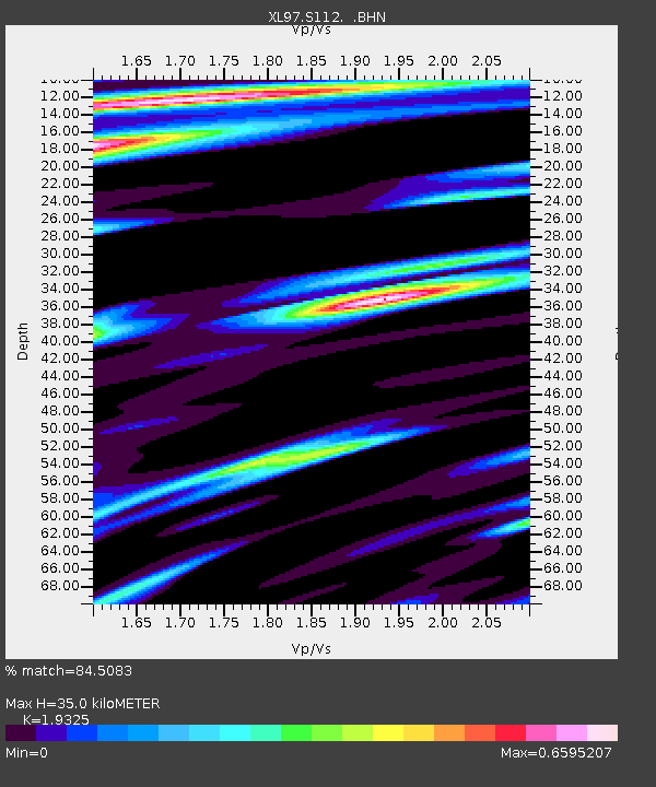
S112 Sandy Bluffs - Earthquake Result Viewer
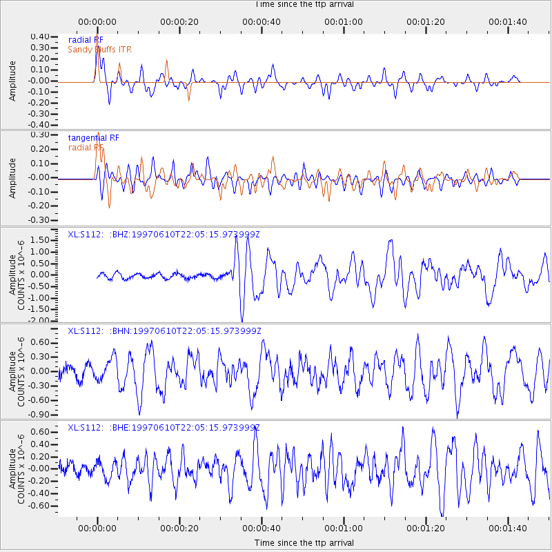
Earthquake location: Southern East Pacific Rise
Earthquake latitude/longitude: -35.8/-108.1
Earthquake time(UTC): 1997/06/10 (161) 21:53:55 GMT
Earthquake Depth: 10 km
Earthquake Magnitude: 5.8 MB, 6.1 MS, 6.5 UNKNOWN, 5.8 MS
Earthquake Catalog/Contributor: WHDF/NEIC
Network: XL Deep Probe (Archean-Proterozoic)
Station: S112 Sandy Bluffs
Lat/Lon: 41.46 N/108.85 W
Elevation: 2138 m
Distance: 76.9 deg
Az: 359.449 deg
Baz: 179.404 deg
Ray Param: 0.050682347
Estimated Moho Depth: 35.0 km
Estimated Crust Vp/Vs: 1.93
Assumed Crust Vp: 6.207 km/s
Estimated Crust Vs: 3.212 km/s
Estimated Crust Poisson's Ratio: 0.32
Radial Match: 84.5083 %
Radial Bump: 400
Transverse Match: 66.270035 %
Transverse Bump: 400
SOD ConfigId: 6273
Insert Time: 2010-03-08 18:15:59.561 +0000
GWidth: 2.5
Max Bumps: 400
Tol: 0.001

Signal To Noise

ChannelStoNSTALTA
XL:S112: :BHN:19970610T22:05:15.973999Z1.96341742.389164E-71.2168395E-7
XL:S112: :BHE:19970610T22:05:15.973999Z1.13541781.3697523E-71.2063862E-7
XL:S112: :BHZ:19970610T22:05:15.973999Z5.5072026.0302733E-71.09497954E-7
Arrivals
Ps5.4 SECOND
PpPs16 SECOND
PsPs/PpSs22 SECOND