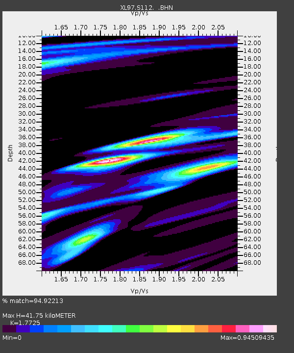
S112 Sandy Bluffs - Earthquake Result Viewer
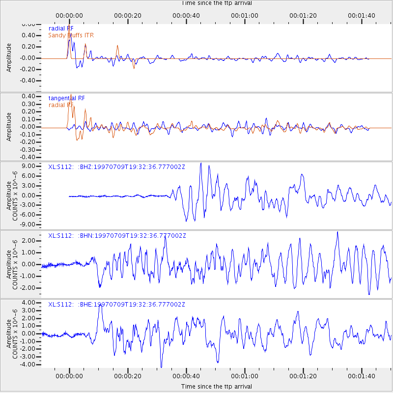
Earthquake location: Near Coast Of Venezuela
Earthquake latitude/longitude: 10.6/-63.5
Earthquake time(UTC): 1997/07/09 (190) 19:24:13 GMT
Earthquake Depth: 20 km
Earthquake Magnitude: 6.2 MB, 6.8 MS, 7.0 UNKNOWN, 6.6 ME
Earthquake Catalog/Contributor: WHDF/NEIC
Network: XL Deep Probe (Archean-Proterozoic)
Station: S112 Sandy Bluffs
Lat/Lon: 41.46 N/108.85 W
Elevation: 2138 m
Distance: 50.2 deg
Az: 315.902 deg
Baz: 114.463 deg
Ray Param: 0.06817263
Estimated Moho Depth: 41.75 km
Estimated Crust Vp/Vs: 1.77
Assumed Crust Vp: 6.207 km/s
Estimated Crust Vs: 3.502 km/s
Estimated Crust Poisson's Ratio: 0.27
Radial Match: 94.92213 %
Radial Bump: 400
Transverse Match: 85.62355 %
Transverse Bump: 400
SOD ConfigId: 6273
Insert Time: 2010-03-08 18:16:02.392 +0000
GWidth: 2.5
Max Bumps: 400
Tol: 0.001

Signal To Noise

ChannelStoNSTALTA
XL:S112: :BHN:19970709T19:32:36.777002Z1.39650891.8964494E-71.357993E-7
XL:S112: :BHE:19970709T19:32:36.777002Z1.59181731.775923E-71.1156576E-7
XL:S112: :BHZ:19970709T19:32:36.777002Z1.24022411.7428142E-71.4052414E-7
Arrivals
Ps5.5 SECOND
PpPs18 SECOND
PsPs/PpSs23 SECOND