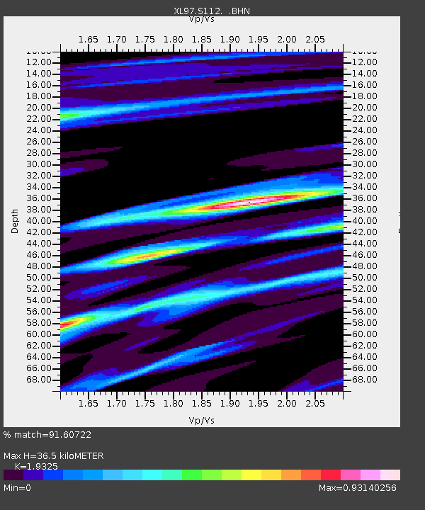
S112 Sandy Bluffs - Earthquake Result Viewer

Earthquake location: Fiji Islands Region
Earthquake latitude/longitude: -15.5/-179.1
Earthquake time(UTC): 1997/08/08 (220) 22:27:19 GMT
Earthquake Depth: 10 km
Earthquake Magnitude: 5.7 MB, 6.6 MS, 6.6 UNKNOWN, 6.4 MW
Earthquake Catalog/Contributor: WHDF/NEIC
Network: XL Deep Probe (Archean-Proterozoic)
Station: S112 Sandy Bluffs
Lat/Lon: 41.46 N/108.85 W
Elevation: 2138 m
Distance: 86.0 deg
Az: 45.18 deg
Baz: 245.493 deg
Ray Param: 0.0443522
Estimated Moho Depth: 36.5 km
Estimated Crust Vp/Vs: 1.93
Assumed Crust Vp: 6.207 km/s
Estimated Crust Vs: 3.212 km/s
Estimated Crust Poisson's Ratio: 0.32
Radial Match: 91.60722 %
Radial Bump: 400
Transverse Match: 79.96752 %
Transverse Bump: 400
SOD ConfigId: 6273
Insert Time: 2010-03-08 18:16:06.508 +0000
GWidth: 2.5
Max Bumps: 400
Tol: 0.001

Signal To Noise

ChannelStoNSTALTA
XL:S112: :BHN:19970808T22:39:28.865002Z1.01124261.878356E-71.8574731E-7
XL:S112: :BHE:19970808T22:39:28.865002Z2.19534562.9463317E-71.3420811E-7
XL:S112: :BHZ:19970808T22:39:28.865002Z1.96901123.2874556E-71.6695971E-7
Arrivals
Ps5.6 SECOND
PpPs17 SECOND
PsPs/PpSs22 SECOND