You are here: Home > Network List > TA - USArray Transportable Network (new EarthScope stations) Stations List
> Station C16K Lisburne Hills, AK, USA > Earthquake Result Viewer
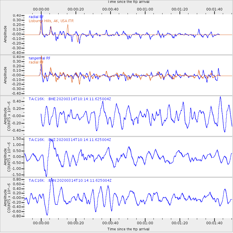
C16K Lisburne Hills, AK, USA - Earthquake Result Viewer
*The percent match for this event was below the threshold and hence no stack was calculated.
| Earthquake location: |
Kermadec Islands Region |
| Earthquake latitude/longitude: |
-27.4/-175.7 |
| Earthquake time(UTC): |
2020/03/14 (074) 10:01:17 GMT |
| Earthquake Depth: |
10 km |
| Earthquake Magnitude: |
6.3 Mww |
| Earthquake Catalog/Contributor: |
NEIC PDE/us |
|
| Network: |
TA USArray Transportable Network (new EarthScope stations) |
| Station: |
C16K Lisburne Hills, AK, USA |
| Lat/Lon: |
68.27 N/165.34 W |
| Elevation: |
102 m |
|
| Distance: |
95.7 deg |
| Az: |
3.851 deg |
| Baz: |
189.228 deg |
| Ray Param: |
$rayparam |
*The percent match for this event was below the threshold and hence was not used in the summary stack. |
|
| Radial Match: |
72.54796 % |
| Radial Bump: |
400 |
| Transverse Match: |
59.434002 % |
| Transverse Bump: |
400 |
| SOD ConfigId: |
20906531 |
| Insert Time: |
2020-04-08 10:33:19.142 +0000 |
| GWidth: |
2.5 |
| Max Bumps: |
400 |
| Tol: |
0.001 |
|
Signal To Noise
| Channel | StoN | STA | LTA |
| TA:C16K: :BHZ:20200314T10:14:11.625004Z | 3.792866 | 7.9269984E-7 | 2.0899759E-7 |
| TA:C16K: :BHN:20200314T10:14:11.625004Z | 3.1751454 | 3.6021052E-7 | 1.13446944E-7 |
| TA:C16K: :BHE:20200314T10:14:11.625004Z | 1.5043974 | 1.997371E-7 | 1.3276885E-7 |
| Arrivals |
| Ps | |
| PpPs | |
| PsPs/PpSs | |


