You are here: Home > Network List > TA - USArray Transportable Network (new EarthScope stations) Stations List
> Station D23K Nanushuk River, AK USA > Earthquake Result Viewer
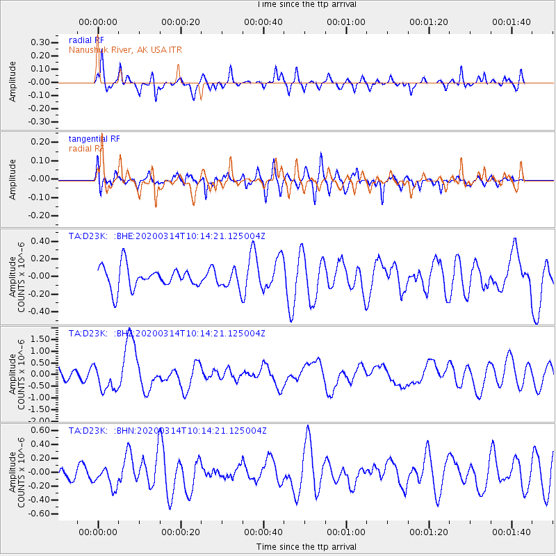
D23K Nanushuk River, AK USA - Earthquake Result Viewer
*The percent match for this event was below the threshold and hence no stack was calculated.
| Earthquake location: |
Kermadec Islands Region |
| Earthquake latitude/longitude: |
-27.4/-175.7 |
| Earthquake time(UTC): |
2020/03/14 (074) 10:01:17 GMT |
| Earthquake Depth: |
10 km |
| Earthquake Magnitude: |
6.3 Mww |
| Earthquake Catalog/Contributor: |
NEIC PDE/us |
|
| Network: |
TA USArray Transportable Network (new EarthScope stations) |
| Station: |
D23K Nanushuk River, AK USA |
| Lat/Lon: |
68.97 N/150.68 W |
| Elevation: |
406 m |
|
| Distance: |
97.8 deg |
| Az: |
8.861 deg |
| Baz: |
202.288 deg |
| Ray Param: |
$rayparam |
*The percent match for this event was below the threshold and hence was not used in the summary stack. |
|
| Radial Match: |
61.748722 % |
| Radial Bump: |
400 |
| Transverse Match: |
55.355618 % |
| Transverse Bump: |
400 |
| SOD ConfigId: |
20906531 |
| Insert Time: |
2020-04-08 10:33:30.171 +0000 |
| GWidth: |
2.5 |
| Max Bumps: |
400 |
| Tol: |
0.001 |
|
Signal To Noise
| Channel | StoN | STA | LTA |
| TA:D23K: :BHZ:20200314T10:14:21.125004Z | 2.4823112 | 5.507163E-7 | 2.2185625E-7 |
| TA:D23K: :BHN:20200314T10:14:21.125004Z | 0.57887137 | 1.5114564E-7 | 2.6110402E-7 |
| TA:D23K: :BHE:20200314T10:14:21.125004Z | 0.8826174 | 1.0881704E-7 | 1.2328903E-7 |
| Arrivals |
| Ps | |
| PpPs | |
| PsPs/PpSs | |


