You are here: Home > Network List > TA - USArray Transportable Network (new EarthScope stations) Stations List
> Station G16K Koyuk River, AK, USA > Earthquake Result Viewer
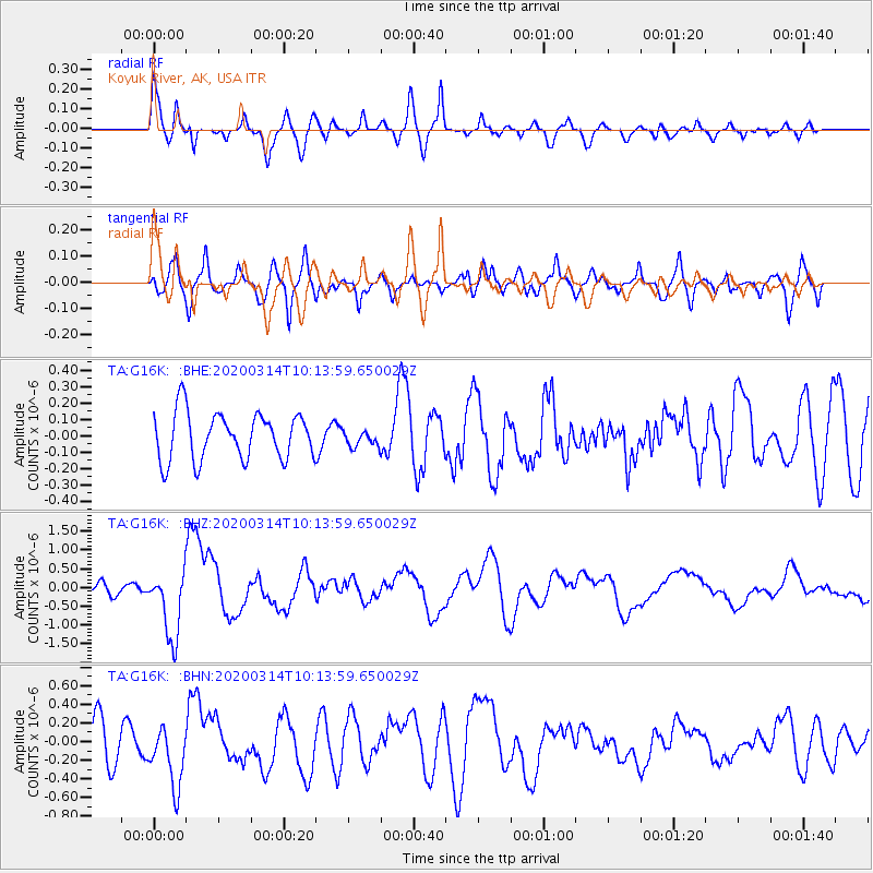
G16K Koyuk River, AK, USA - Earthquake Result Viewer
*The percent match for this event was below the threshold and hence no stack was calculated.
| Earthquake location: |
Kermadec Islands Region |
| Earthquake latitude/longitude: |
-27.4/-175.7 |
| Earthquake time(UTC): |
2020/03/14 (074) 10:01:17 GMT |
| Earthquake Depth: |
10 km |
| Earthquake Magnitude: |
6.3 Mww |
| Earthquake Catalog/Contributor: |
NEIC PDE/us |
|
| Network: |
TA USArray Transportable Network (new EarthScope stations) |
| Station: |
G16K Koyuk River, AK, USA |
| Lat/Lon: |
65.39 N/162.35 W |
| Elevation: |
169 m |
|
| Distance: |
93.1 deg |
| Az: |
5.548 deg |
| Baz: |
191.844 deg |
| Ray Param: |
$rayparam |
*The percent match for this event was below the threshold and hence was not used in the summary stack. |
|
| Radial Match: |
71.13113 % |
| Radial Bump: |
400 |
| Transverse Match: |
69.928856 % |
| Transverse Bump: |
400 |
| SOD ConfigId: |
20906531 |
| Insert Time: |
2020-04-08 10:33:59.518 +0000 |
| GWidth: |
2.5 |
| Max Bumps: |
400 |
| Tol: |
0.001 |
|
Signal To Noise
| Channel | StoN | STA | LTA |
| TA:G16K: :BHZ:20200314T10:13:59.650029Z | 7.2811527 | 9.207036E-7 | 1.2645025E-7 |
| TA:G16K: :BHN:20200314T10:13:59.650029Z | 1.8281254 | 3.231145E-7 | 1.7674637E-7 |
| TA:G16K: :BHE:20200314T10:13:59.650029Z | 0.34757525 | 5.0000658E-8 | 1.4385564E-7 |
| Arrivals |
| Ps | |
| PpPs | |
| PsPs/PpSs | |


