You are here: Home > Network List > TA - USArray Transportable Network (new EarthScope stations) Stations List
> Station I30M Mount Dempster, Yukon, CAN > Earthquake Result Viewer
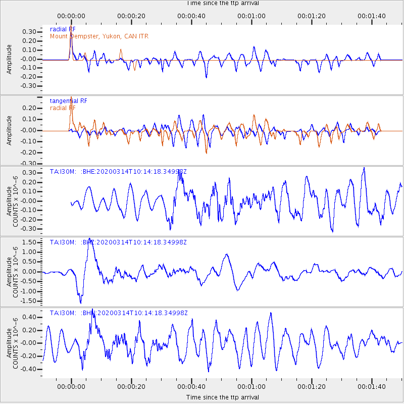
I30M Mount Dempster, Yukon, CAN - Earthquake Result Viewer
*The percent match for this event was below the threshold and hence no stack was calculated.
| Earthquake location: |
Kermadec Islands Region |
| Earthquake latitude/longitude: |
-27.4/-175.7 |
| Earthquake time(UTC): |
2020/03/14 (074) 10:01:17 GMT |
| Earthquake Depth: |
10 km |
| Earthquake Magnitude: |
6.3 Mww |
| Earthquake Catalog/Contributor: |
NEIC PDE/us |
|
| Network: |
TA USArray Transportable Network (new EarthScope stations) |
| Station: |
I30M Mount Dempster, Yukon, CAN |
| Lat/Lon: |
65.22 N/136.38 W |
| Elevation: |
1399 m |
|
| Distance: |
97.2 deg |
| Az: |
15.61 deg |
| Baz: |
214.584 deg |
| Ray Param: |
$rayparam |
*The percent match for this event was below the threshold and hence was not used in the summary stack. |
|
| Radial Match: |
74.61375 % |
| Radial Bump: |
400 |
| Transverse Match: |
54.5062 % |
| Transverse Bump: |
400 |
| SOD ConfigId: |
20906531 |
| Insert Time: |
2020-04-08 10:34:25.189 +0000 |
| GWidth: |
2.5 |
| Max Bumps: |
400 |
| Tol: |
0.001 |
|
Signal To Noise
| Channel | StoN | STA | LTA |
| TA:I30M: :BHZ:20200314T10:14:18.34998Z | 14.95343 | 7.484524E-7 | 5.0052222E-8 |
| TA:I30M: :BHN:20200314T10:14:18.34998Z | 1.2584054 | 1.5500808E-7 | 1.2317818E-7 |
| TA:I30M: :BHE:20200314T10:14:18.34998Z | 1.5019318 | 1.4086287E-7 | 9.378779E-8 |
| Arrivals |
| Ps | |
| PpPs | |
| PsPs/PpSs | |


