You are here: Home > Network List > TA - USArray Transportable Network (new EarthScope stations) Stations List
> Station M17K Holitna River, AK, USA > Earthquake Result Viewer
M17K Holitna River, AK, USA - Earthquake Result Viewer
| Earthquake location: |
Kermadec Islands Region |
| Earthquake latitude/longitude: |
-27.4/-175.7 |
| Earthquake time(UTC): |
2020/03/14 (074) 10:01:17 GMT |
| Earthquake Depth: |
10 km |
| Earthquake Magnitude: |
6.3 Mww |
| Earthquake Catalog/Contributor: |
NEIC PDE/us |
|
| Network: |
TA USArray Transportable Network (new EarthScope stations) |
| Station: |
M17K Holitna River, AK, USA |
| Lat/Lon: |
61.40 N/157.44 W |
| Elevation: |
387 m |
|
| Distance: |
89.7 deg |
| Az: |
8.665 deg |
| Baz: |
196.161 deg |
| Ray Param: |
0.041732393 |
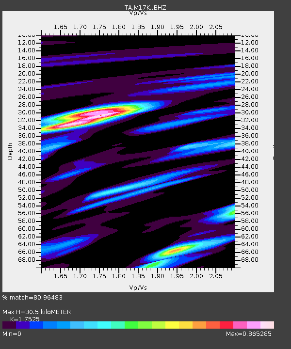
| Estimated Moho Depth: |
30.5 km |
| Estimated Crust Vp/Vs: |
1.75 |
| Assumed Crust Vp: |
6.155 km/s |
| Estimated Crust Vs: |
3.512 km/s |
| Estimated Crust Poisson's Ratio: |
0.26 |
|
| Radial Match: |
80.96483 % |
| Radial Bump: |
400 |
| Transverse Match: |
68.41399 % |
| Transverse Bump: |
400 |
| SOD ConfigId: |
20906531 |
| Insert Time: |
2020-04-08 10:34:51.999 +0000 |
| GWidth: |
2.5 |
| Max Bumps: |
400 |
| Tol: |
0.001 |
|

Signal To Noise
| Channel | StoN | STA | LTA |
| TA:M17K: :BHZ:20200314T10:13:44.174992Z | 9.693984 | 2.1205099E-6 | 2.1874494E-7 |
| TA:M17K: :BHN:20200314T10:13:44.174992Z | 2.449793 | 6.533589E-7 | 2.6669963E-7 |
| TA:M17K: :BHE:20200314T10:13:44.174992Z | 1.944865 | 6.6711783E-7 | 3.43015E-7 |
| Arrivals |
| Ps | 3.8 SECOND |
| PpPs | 13 SECOND |
| PsPs/PpSs | 17 SECOND |


