You are here: Home > Network List > TA - USArray Transportable Network (new EarthScope stations) Stations List
> Station M31M Drury Creek, Yukon, CA > Earthquake Result Viewer
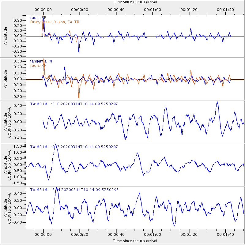
M31M Drury Creek, Yukon, CA - Earthquake Result Viewer
*The percent match for this event was below the threshold and hence no stack was calculated.
| Earthquake location: |
Kermadec Islands Region |
| Earthquake latitude/longitude: |
-27.4/-175.7 |
| Earthquake time(UTC): |
2020/03/14 (074) 10:01:17 GMT |
| Earthquake Depth: |
10 km |
| Earthquake Magnitude: |
6.3 Mww |
| Earthquake Catalog/Contributor: |
NEIC PDE/us |
|
| Network: |
TA USArray Transportable Network (new EarthScope stations) |
| Station: |
M31M Drury Creek, Yukon, CA |
| Lat/Lon: |
62.20 N/134.39 W |
| Elevation: |
639 m |
|
| Distance: |
95.3 deg |
| Az: |
18.1 deg |
| Baz: |
216.092 deg |
| Ray Param: |
$rayparam |
*The percent match for this event was below the threshold and hence was not used in the summary stack. |
|
| Radial Match: |
76.2589 % |
| Radial Bump: |
381 |
| Transverse Match: |
56.78167 % |
| Transverse Bump: |
400 |
| SOD ConfigId: |
20906531 |
| Insert Time: |
2020-04-08 10:35:02.509 +0000 |
| GWidth: |
2.5 |
| Max Bumps: |
400 |
| Tol: |
0.001 |
|
Signal To Noise
| Channel | StoN | STA | LTA |
| TA:M31M: :BHZ:20200314T10:14:09.525029Z | 6.2560463 | 5.9699926E-7 | 9.5427566E-8 |
| TA:M31M: :BHN:20200314T10:14:09.525029Z | 1.6213841 | 1.9462142E-7 | 1.2003412E-7 |
| TA:M31M: :BHE:20200314T10:14:09.525029Z | 1.0411656 | 9.274152E-8 | 8.907472E-8 |
| Arrivals |
| Ps | |
| PpPs | |
| PsPs/PpSs | |


