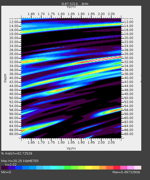
S210 Tin Can Draw - Earthquake Result Viewer
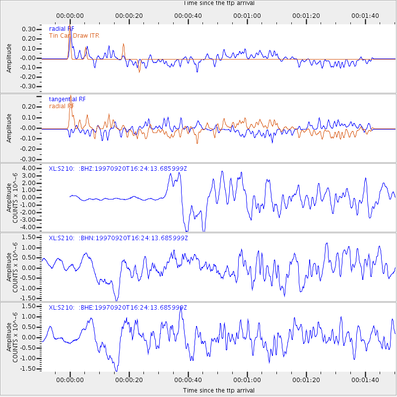
Earthquake location: Kermadec Islands Region
Earthquake latitude/longitude: -28.7/-177.6
Earthquake time(UTC): 1997/09/20 (263) 16:11:32 GMT
Earthquake Depth: 30 km
Earthquake Magnitude: 6.1 MB, 7.0 MS, 7.2 UNKNOWN, 6.7 ME
Earthquake Catalog/Contributor: WHDF/NEIC
Network: XL Deep Probe (Archean-Proterozoic)
Station: S210 Tin Can Draw
Lat/Lon: 41.32 N/110.03 W
Elevation: 2084 m
Distance: 93.5 deg
Az: 44.244 deg
Baz: 234.472 deg
Ray Param: 0.041231625
Estimated Moho Depth: 30.25 km
Estimated Crust Vp/Vs: 2.02
Assumed Crust Vp: 6.155 km/s
Estimated Crust Vs: 3.047 km/s
Estimated Crust Poisson's Ratio: 0.34
Radial Match: 82.72526 %
Radial Bump: 400
Transverse Match: 66.41645 %
Transverse Bump: 400
SOD ConfigId: 6273
Insert Time: 2010-03-08 18:16:27.425 +0000
GWidth: 2.5
Max Bumps: 400
Tol: 0.001

Signal To Noise

ChannelStoNSTALTA
XL:S210: :BHN:19970920T16:24:13.685999Z0.711586362.2273912E-73.130177E-7
XL:S210: :BHE:19970920T16:24:13.685999Z1.28547612.3491525E-71.8274571E-7
XL:S210: :BHZ:19970920T16:24:13.685999Z8.7363491.5255882E-61.7462537E-7
Arrivals
Ps5.1 SECOND
PpPs15 SECOND
PsPs/PpSs20 SECOND