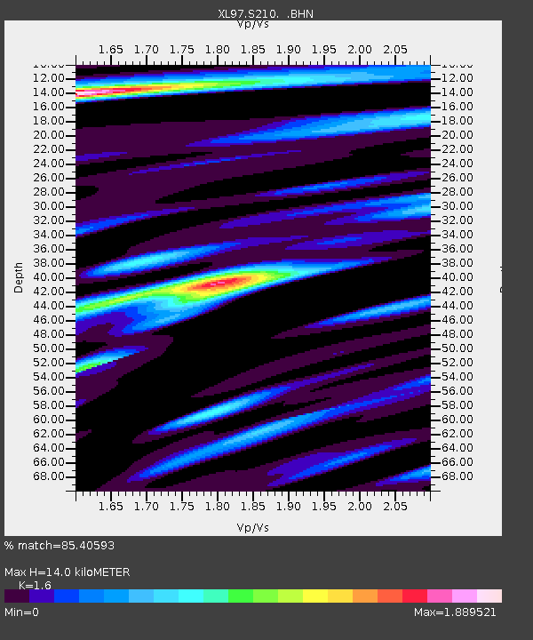
S210 Tin Can Draw - Earthquake Result Viewer
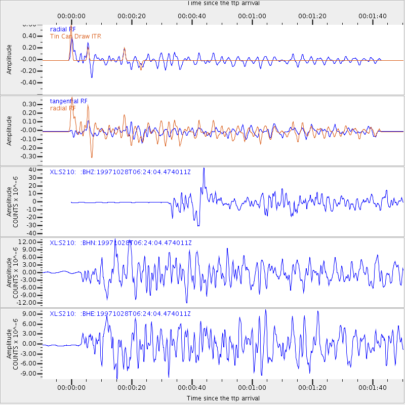
Earthquake location: Northern Peru
Earthquake latitude/longitude: -4.4/-76.7
Earthquake time(UTC): 1997/10/28 (301) 06:15:17 GMT
Earthquake Depth: 112 km
Earthquake Magnitude: 6.6 MB, 6.3 MS, 7.2 UNKNOWN, 6.6 ME
Earthquake Catalog/Contributor: WHDF/NEIC
Network: XL Deep Probe (Archean-Proterozoic)
Station: S210 Tin Can Draw
Lat/Lon: 41.32 N/110.03 W
Elevation: 2084 m
Distance: 54.7 deg
Az: 329.511 deg
Baz: 137.808 deg
Ray Param: 0.06491652
Estimated Moho Depth: 14.0 km
Estimated Crust Vp/Vs: 1.60
Assumed Crust Vp: 6.155 km/s
Estimated Crust Vs: 3.847 km/s
Estimated Crust Poisson's Ratio: 0.18
Radial Match: 85.40593 %
Radial Bump: 400
Transverse Match: 85.820145 %
Transverse Bump: 400
SOD ConfigId: 6273
Insert Time: 2010-03-08 18:16:29.216 +0000
GWidth: 2.5
Max Bumps: 400
Tol: 0.001

Signal To Noise

ChannelStoNSTALTA
XL:S210: :BHN:19971028T06:24:04.474011Z3.20655921.0311564E-63.2157723E-7
XL:S210: :BHE:19971028T06:24:04.474011Z6.9024491.081822E-61.5673017E-7
XL:S210: :BHZ:19971028T06:24:04.474011Z23.5665.1479387E-62.1844771E-7
Arrivals
Ps1.4 SECOND
PpPs5.6 SECOND
PsPs/PpSs7.0 SECOND