You are here: Home > Network List > TS - TERRAscope (Southern California Seismic Network) Stations List
> Station PFO Pinon Flat, California, USA > Earthquake Result Viewer
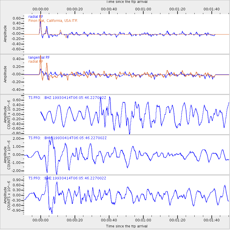
PFO Pinon Flat, California, USA - Earthquake Result Viewer
*The percent match for this event was below the threshold and hence no stack was calculated.
| Earthquake location: |
Fox Islands, Aleutian Islands |
| Earthquake latitude/longitude: |
51.3/-168.8 |
| Earthquake time(UTC): |
1993/04/14 (104) 05:58:32 GMT |
| Earthquake Depth: |
33 km |
| Earthquake Magnitude: |
5.6 MB, 5.4 MS |
| Earthquake Catalog/Contributor: |
WHDF/NEIC |
|
| Network: |
TS TERRAscope (Southern California Seismic Network) |
| Station: |
PFO Pinon Flat, California, USA |
| Lat/Lon: |
33.61 N/116.46 W |
| Elevation: |
1280 m |
|
| Distance: |
41.5 deg |
| Az: |
94.372 deg |
| Baz: |
311.341 deg |
| Ray Param: |
$rayparam |
*The percent match for this event was below the threshold and hence was not used in the summary stack. |
|
| Radial Match: |
78.71367 % |
| Radial Bump: |
385 |
| Transverse Match: |
64.66328 % |
| Transverse Bump: |
400 |
| SOD ConfigId: |
4480 |
| Insert Time: |
2010-02-26 14:44:07.010 +0000 |
| GWidth: |
2.5 |
| Max Bumps: |
400 |
| Tol: |
0.001 |
|
Signal To Noise
| Channel | StoN | STA | LTA |
| TS:PFO: :BHN:19930414T06:05:46.227002Z | 3.557881 | 8.2130737E-7 | 2.308417E-7 |
| TS:PFO: :BHE:19930414T06:05:46.227002Z | 2.5479736 | 4.627668E-7 | 1.816215E-7 |
| TS:PFO: :BHZ:19930414T06:05:46.227002Z | 1.1629437 | 2.5876528E-7 | 2.2250885E-7 |
| Arrivals |
| Ps | |
| PpPs | |
| PsPs/PpSs | |


