You are here: Home > Network List > TX - Texas Seismological Network Stations List
> Station MB05 Klondike > Earthquake Result Viewer
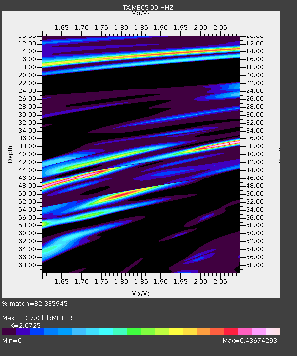
MB05 Klondike - Earthquake Result Viewer
| Earthquake location: |
Kermadec Islands Region |
| Earthquake latitude/longitude: |
-27.4/-175.7 |
| Earthquake time(UTC): |
2020/03/14 (074) 10:01:17 GMT |
| Earthquake Depth: |
10 km |
| Earthquake Magnitude: |
6.3 Mww |
| Earthquake Catalog/Contributor: |
NEIC PDE/us |
|
| Network: |
TX Texas Seismological Network |
| Station: |
MB05 Klondike |
| Lat/Lon: |
32.63 N/101.86 W |
| Elevation: |
882 m |
|
| Distance: |
92.1 deg |
| Az: |
54.193 deg |
| Baz: |
238.683 deg |
| Ray Param: |
0.041512072 |
| Estimated Moho Depth: |
37.0 km |
| Estimated Crust Vp/Vs: |
2.07 |
| Assumed Crust Vp: |
6.426 km/s |
| Estimated Crust Vs: |
3.101 km/s |
| Estimated Crust Poisson's Ratio: |
0.35 |
|
| Radial Match: |
82.335945 % |
| Radial Bump: |
400 |
| Transverse Match: |
59.961227 % |
| Transverse Bump: |
400 |
| SOD ConfigId: |
20906531 |
| Insert Time: |
2020-04-08 10:37:17.013 +0000 |
| GWidth: |
2.5 |
| Max Bumps: |
400 |
| Tol: |
0.001 |
|

Signal To Noise
| Channel | StoN | STA | LTA |
| TX:MB05:00:HHZ:20200314T10:13:55.159978Z | 12.539876 | 7.466791E-7 | 5.954438E-8 |
| TX:MB05:00:HH1:20200314T10:13:55.159978Z | 1.5618439 | 1.07975985E-7 | 6.913366E-8 |
| TX:MB05:00:HH2:20200314T10:13:55.159978Z | 2.5329828 | 2.063392E-7 | 8.146095E-8 |
| Arrivals |
| Ps | 6.3 SECOND |
| PpPs | 17 SECOND |
| PsPs/PpSs | 24 SECOND |


