You are here: Home > Network List > TX - Texas Seismological Network Stations List
> Station PB08 Permian Basin 08 > Earthquake Result Viewer
PB08 Permian Basin 08 - Earthquake Result Viewer
| Earthquake location: |
Kermadec Islands Region |
| Earthquake latitude/longitude: |
-27.4/-175.7 |
| Earthquake time(UTC): |
2020/03/14 (074) 10:01:17 GMT |
| Earthquake Depth: |
10 km |
| Earthquake Magnitude: |
6.3 Mww |
| Earthquake Catalog/Contributor: |
NEIC PDE/us |
|
| Network: |
TX Texas Seismological Network |
| Station: |
PB08 Permian Basin 08 |
| Lat/Lon: |
30.89 N/102.91 W |
| Elevation: |
926 m |
|
| Distance: |
90.4 deg |
| Az: |
55.198 deg |
| Baz: |
238.112 deg |
| Ray Param: |
0.04170342 |
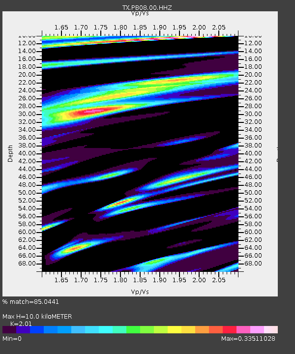
| Estimated Moho Depth: |
10.0 km |
| Estimated Crust Vp/Vs: |
2.01 |
| Assumed Crust Vp: |
6.121 km/s |
| Estimated Crust Vs: |
3.045 km/s |
| Estimated Crust Poisson's Ratio: |
0.34 |
|
| Radial Match: |
85.0441 % |
| Radial Bump: |
349 |
| Transverse Match: |
73.573524 % |
| Transverse Bump: |
400 |
| SOD ConfigId: |
20906531 |
| Insert Time: |
2020-04-08 10:37:36.077 +0000 |
| GWidth: |
2.5 |
| Max Bumps: |
400 |
| Tol: |
0.001 |
|

Signal To Noise
| Channel | StoN | STA | LTA |
| TX:PB08:00:HHZ:20200314T10:13:47.460026Z | 6.5363393 | 1.0428437E-6 | 1.5954552E-7 |
| TX:PB08:00:HH1:20200314T10:13:47.460026Z | 2.8637621 | 2.2592903E-7 | 7.8892384E-8 |
| TX:PB08:00:HH2:20200314T10:13:47.460026Z | 0.6387472 | 9.3198025E-8 | 1.4590752E-7 |
| Arrivals |
| Ps | 1.7 SECOND |
| PpPs | 4.8 SECOND |
| PsPs/PpSs | 6.5 SECOND |


