You are here: Home > Network List > TX - Texas Seismological Network Stations List
> Station PB09 Culberson County > Earthquake Result Viewer
PB09 Culberson County - Earthquake Result Viewer
| Earthquake location: |
Kermadec Islands Region |
| Earthquake latitude/longitude: |
-27.4/-175.7 |
| Earthquake time(UTC): |
2020/03/14 (074) 10:01:17 GMT |
| Earthquake Depth: |
10 km |
| Earthquake Magnitude: |
6.3 Mww |
| Earthquake Catalog/Contributor: |
NEIC PDE/us |
|
| Network: |
TX Texas Seismological Network |
| Station: |
PB09 Culberson County |
| Lat/Lon: |
31.77 N/104.30 W |
| Elevation: |
1139 m |
|
| Distance: |
89.9 deg |
| Az: |
53.818 deg |
| Baz: |
237.395 deg |
| Ray Param: |
0.041728985 |
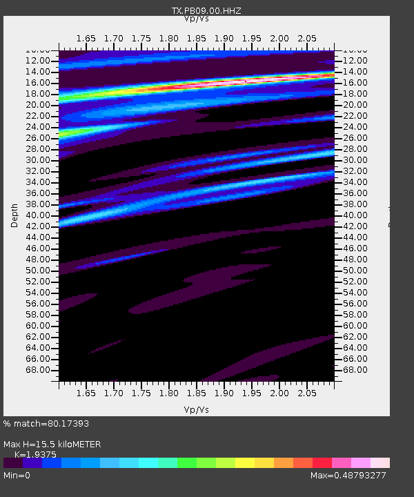
| Estimated Moho Depth: |
15.5 km |
| Estimated Crust Vp/Vs: |
1.94 |
| Assumed Crust Vp: |
6.361 km/s |
| Estimated Crust Vs: |
3.283 km/s |
| Estimated Crust Poisson's Ratio: |
0.32 |
|
| Radial Match: |
80.17393 % |
| Radial Bump: |
400 |
| Transverse Match: |
61.220516 % |
| Transverse Bump: |
400 |
| SOD ConfigId: |
20906531 |
| Insert Time: |
2020-04-08 10:37:38.641 +0000 |
| GWidth: |
2.5 |
| Max Bumps: |
400 |
| Tol: |
0.001 |
|

Signal To Noise
| Channel | StoN | STA | LTA |
| TX:PB09:00:HHZ:20200314T10:13:44.960026Z | 5.7792864 | 1.441003E-6 | 2.4933925E-7 |
| TX:PB09:00:HHN:20200314T10:13:44.960026Z | 1.294319 | 3.5875954E-7 | 2.7718013E-7 |
| TX:PB09:00:HHE:20200314T10:13:44.960026Z | 2.1234639 | 3.401296E-7 | 1.6017677E-7 |
| Arrivals |
| Ps | 2.3 SECOND |
| PpPs | 7.0 SECOND |
| PsPs/PpSs | 9.4 SECOND |


