You are here: Home > Network List > TX - Texas Seismological Network Stations List
> Station PB10 Southeast of Toyah > Earthquake Result Viewer
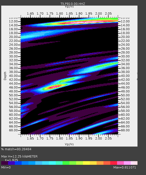
PB10 Southeast of Toyah - Earthquake Result Viewer
| Earthquake location: |
Kermadec Islands Region |
| Earthquake latitude/longitude: |
-27.4/-175.7 |
| Earthquake time(UTC): |
2020/03/14 (074) 10:01:17 GMT |
| Earthquake Depth: |
10 km |
| Earthquake Magnitude: |
6.3 Mww |
| Earthquake Catalog/Contributor: |
NEIC PDE/us |
|
| Network: |
TX Texas Seismological Network |
| Station: |
PB10 Southeast of Toyah |
| Lat/Lon: |
31.28 N/103.75 W |
| Elevation: |
858 m |
|
| Distance: |
90.0 deg |
| Az: |
54.481 deg |
| Baz: |
237.68 deg |
| Ray Param: |
0.04172475 |
| Estimated Moho Depth: |
12.25 km |
| Estimated Crust Vp/Vs: |
1.92 |
| Assumed Crust Vp: |
6.121 km/s |
| Estimated Crust Vs: |
3.179 km/s |
| Estimated Crust Poisson's Ratio: |
0.32 |
|
| Radial Match: |
80.28484 % |
| Radial Bump: |
400 |
| Transverse Match: |
50.12491 % |
| Transverse Bump: |
400 |
| SOD ConfigId: |
20906531 |
| Insert Time: |
2020-04-08 10:37:39.151 +0000 |
| GWidth: |
2.5 |
| Max Bumps: |
400 |
| Tol: |
0.001 |
|

Signal To Noise
| Channel | StoN | STA | LTA |
| TX:PB10:00:HHZ:20200314T10:13:45.570012Z | 8.579772 | 1.2771354E-6 | 1.4885423E-7 |
| TX:PB10:00:HH1:20200314T10:13:45.570012Z | 2.5081499 | 4.104766E-7 | 1.6365712E-7 |
| TX:PB10:00:HH2:20200314T10:13:45.570012Z | 2.8034842 | 3.4806527E-7 | 1.2415452E-7 |
| Arrivals |
| Ps | 1.9 SECOND |
| PpPs | 5.8 SECOND |
| PsPs/PpSs | 7.6 SECOND |


