You are here: Home > Network List > US - United States National Seismic Network Stations List
> Station EGMT Eagleton, Montana, USA > Earthquake Result Viewer
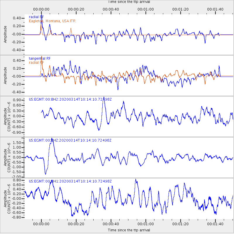
EGMT Eagleton, Montana, USA - Earthquake Result Viewer
*The percent match for this event was below the threshold and hence no stack was calculated.
| Earthquake location: |
Kermadec Islands Region |
| Earthquake latitude/longitude: |
-27.4/-175.7 |
| Earthquake time(UTC): |
2020/03/14 (074) 10:01:17 GMT |
| Earthquake Depth: |
10 km |
| Earthquake Magnitude: |
6.3 Mww |
| Earthquake Catalog/Contributor: |
NEIC PDE/us |
|
| Network: |
US United States National Seismic Network |
| Station: |
EGMT Eagleton, Montana, USA |
| Lat/Lon: |
48.02 N/109.75 W |
| Elevation: |
1055 m |
|
| Distance: |
95.5 deg |
| Az: |
38.009 deg |
| Baz: |
234.627 deg |
| Ray Param: |
$rayparam |
*The percent match for this event was below the threshold and hence was not used in the summary stack. |
|
| Radial Match: |
72.954475 % |
| Radial Bump: |
400 |
| Transverse Match: |
59.42271 % |
| Transverse Bump: |
400 |
| SOD ConfigId: |
20906531 |
| Insert Time: |
2020-04-08 10:39:09.949 +0000 |
| GWidth: |
2.5 |
| Max Bumps: |
400 |
| Tol: |
0.001 |
|
Signal To Noise
| Channel | StoN | STA | LTA |
| US:EGMT:00:BHZ:20200314T10:14:10.72498Z | 9.008807 | 8.5551017E-7 | 9.496377E-8 |
| US:EGMT:00:BH1:20200314T10:14:10.72498Z | 1.239366 | 3.376962E-7 | 2.7247498E-7 |
| US:EGMT:00:BH2:20200314T10:14:10.72498Z | 1.6433461 | 3.9014859E-7 | 2.3741109E-7 |
| Arrivals |
| Ps | |
| PpPs | |
| PsPs/PpSs | |


