You are here: Home > Network List > US - United States National Seismic Network Stations List
> Station LAO LASA Array, Montana, USA > Earthquake Result Viewer
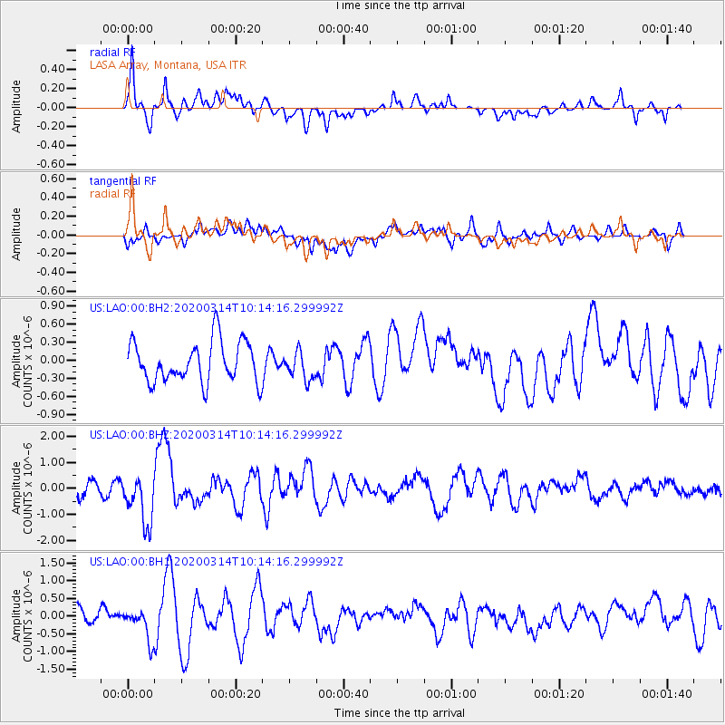
LAO LASA Array, Montana, USA - Earthquake Result Viewer
*The percent match for this event was below the threshold and hence no stack was calculated.
| Earthquake location: |
Kermadec Islands Region |
| Earthquake latitude/longitude: |
-27.4/-175.7 |
| Earthquake time(UTC): |
2020/03/14 (074) 10:01:17 GMT |
| Earthquake Depth: |
10 km |
| Earthquake Magnitude: |
6.3 Mww |
| Earthquake Catalog/Contributor: |
NEIC PDE/us |
|
| Network: |
US United States National Seismic Network |
| Station: |
LAO LASA Array, Montana, USA |
| Lat/Lon: |
46.69 N/106.22 W |
| Elevation: |
902 m |
|
| Distance: |
96.8 deg |
| Az: |
40.477 deg |
| Baz: |
236.953 deg |
| Ray Param: |
$rayparam |
*The percent match for this event was below the threshold and hence was not used in the summary stack. |
|
| Radial Match: |
74.24897 % |
| Radial Bump: |
400 |
| Transverse Match: |
59.88214 % |
| Transverse Bump: |
400 |
| SOD ConfigId: |
20906531 |
| Insert Time: |
2020-04-08 10:39:20.627 +0000 |
| GWidth: |
2.5 |
| Max Bumps: |
400 |
| Tol: |
0.001 |
|
Signal To Noise
| Channel | StoN | STA | LTA |
| US:LAO:00:BHZ:20200314T10:14:16.299992Z | 3.6293259 | 9.678168E-7 | 2.6666572E-7 |
| US:LAO:00:BH1:20200314T10:14:16.299992Z | 2.5464685 | 4.6323632E-7 | 1.8191322E-7 |
| US:LAO:00:BH2:20200314T10:14:16.299992Z | 0.71077055 | 2.4007412E-7 | 3.3776598E-7 |
| Arrivals |
| Ps | |
| PpPs | |
| PsPs/PpSs | |


