You are here: Home > Network List > UU - University of Utah Regional Network Stations List
> Station FORU South Mineral Mountains, UT, USA > Earthquake Result Viewer
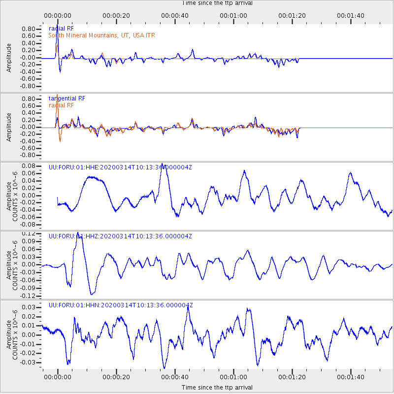
FORU South Mineral Mountains, UT, USA - Earthquake Result Viewer
*The percent match for this event was below the threshold and hence no stack was calculated.
| Earthquake location: |
Kermadec Islands Region |
| Earthquake latitude/longitude: |
-27.4/-175.7 |
| Earthquake time(UTC): |
2020/03/14 (074) 10:01:17 GMT |
| Earthquake Depth: |
10 km |
| Earthquake Magnitude: |
6.3 Mww |
| Earthquake Catalog/Contributor: |
NEIC PDE/us |
|
| Network: |
UU University of Utah Regional Network |
| Station: |
FORU South Mineral Mountains, UT, USA |
| Lat/Lon: |
38.46 N/112.86 W |
| Elevation: |
1840 m |
|
| Distance: |
88.0 deg |
| Az: |
44.334 deg |
| Baz: |
232.304 deg |
| Ray Param: |
$rayparam |
*The percent match for this event was below the threshold and hence was not used in the summary stack. |
|
| Radial Match: |
74.660774 % |
| Radial Bump: |
400 |
| Transverse Match: |
67.01832 % |
| Transverse Bump: |
363 |
| SOD ConfigId: |
20906531 |
| Insert Time: |
2020-04-08 10:39:58.184 +0000 |
| GWidth: |
2.5 |
| Max Bumps: |
400 |
| Tol: |
0.001 |
|
Signal To Noise
| Channel | StoN | STA | LTA |
| UU:FORU:01:HHZ:20200314T10:13:36.000004Z | 10.171738 | 3.8023206E-8 | 3.7381227E-9 |
| UU:FORU:01:HHN:20200314T10:13:36.000004Z | 1.7801828 | 1.5026806E-8 | 8.441159E-9 |
| UU:FORU:01:HHE:20200314T10:13:36.000004Z | 0.2814126 | 9.140166E-9 | 3.2479587E-8 |
| Arrivals |
| Ps | |
| PpPs | |
| PsPs/PpSs | |


