You are here: Home > Network List > UW - Pacific Northwest Regional Seismic Network Stations List
> Station GNW Green Mountain (BB) > Earthquake Result Viewer
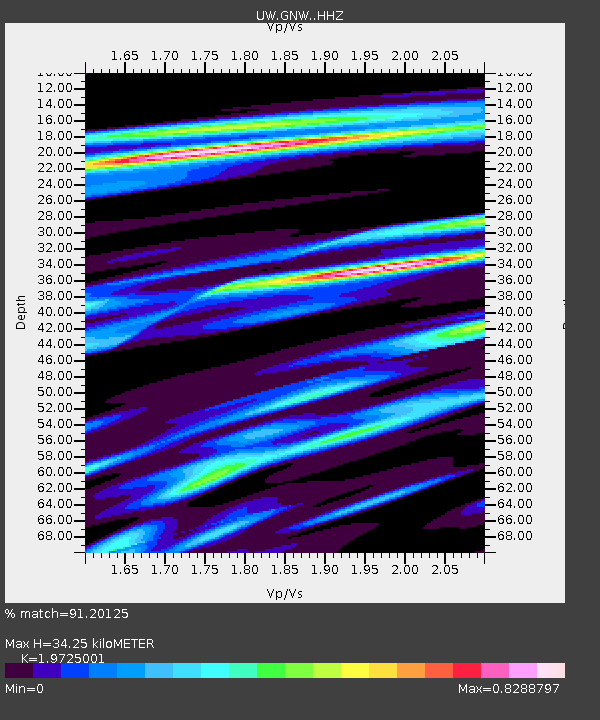
GNW Green Mountain (BB) - Earthquake Result Viewer
| Earthquake location: |
Kermadec Islands Region |
| Earthquake latitude/longitude: |
-27.4/-175.7 |
| Earthquake time(UTC): |
2020/03/14 (074) 10:01:17 GMT |
| Earthquake Depth: |
10 km |
| Earthquake Magnitude: |
6.3 Mww |
| Earthquake Catalog/Contributor: |
NEIC PDE/us |
|
| Network: |
UW Pacific Northwest Regional Seismic Network |
| Station: |
GNW Green Mountain (BB) |
| Lat/Lon: |
47.56 N/122.83 W |
| Elevation: |
160 m |
|
| Distance: |
88.5 deg |
| Az: |
32.687 deg |
| Baz: |
225.142 deg |
| Ray Param: |
0.04255228 |
| Estimated Moho Depth: |
34.25 km |
| Estimated Crust Vp/Vs: |
1.97 |
| Assumed Crust Vp: |
6.566 km/s |
| Estimated Crust Vs: |
3.329 km/s |
| Estimated Crust Poisson's Ratio: |
0.33 |
|
| Radial Match: |
91.20125 % |
| Radial Bump: |
400 |
| Transverse Match: |
76.15667 % |
| Transverse Bump: |
400 |
| SOD ConfigId: |
20906531 |
| Insert Time: |
2020-04-08 10:41:00.251 +0000 |
| GWidth: |
2.5 |
| Max Bumps: |
400 |
| Tol: |
0.001 |
|

Signal To Noise
| Channel | StoN | STA | LTA |
| UW:GNW: :HHZ:20200314T10:13:38.330021Z | 7.420689 | 1.7398189E-6 | 2.3445519E-7 |
| UW:GNW: :HHN:20200314T10:13:38.330021Z | 3.379338 | 5.7478405E-7 | 1.7008776E-7 |
| UW:GNW: :HHE:20200314T10:13:38.330021Z | 3.0135705 | 4.2896363E-7 | 1.4234398E-7 |
| Arrivals |
| Ps | 5.2 SECOND |
| PpPs | 15 SECOND |
| PsPs/PpSs | 20 SECOND |


