You are here: Home > Network List > TS - TERRAscope (Southern California Seismic Network) Stations List
> Station PFO Pinon Flat, California, USA > Earthquake Result Viewer
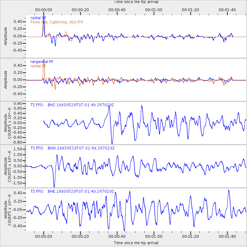
PFO Pinon Flat, California, USA - Earthquake Result Viewer
*The percent match for this event was below the threshold and hence no stack was calculated.
| Earthquake location: |
North Atlantic Ocean |
| Earthquake latitude/longitude: |
19.1/-26.5 |
| Earthquake time(UTC): |
1993/05/29 (149) 06:50:13 GMT |
| Earthquake Depth: |
10 km |
| Earthquake Magnitude: |
5.9 MB, 6.2 MS, 6.2 UNKNOWN |
| Earthquake Catalog/Contributor: |
WHDF/NEIC |
|
| Network: |
TS TERRAscope (Southern California Seismic Network) |
| Station: |
PFO Pinon Flat, California, USA |
| Lat/Lon: |
33.61 N/116.46 W |
| Elevation: |
1280 m |
|
| Distance: |
79.7 deg |
| Az: |
301.974 deg |
| Baz: |
74.033 deg |
| Ray Param: |
$rayparam |
*The percent match for this event was below the threshold and hence was not used in the summary stack. |
|
| Radial Match: |
73.832016 % |
| Radial Bump: |
395 |
| Transverse Match: |
75.56434 % |
| Transverse Bump: |
400 |
| SOD ConfigId: |
4480 |
| Insert Time: |
2010-02-26 14:44:09.842 +0000 |
| GWidth: |
2.5 |
| Max Bumps: |
400 |
| Tol: |
0.001 |
|
Signal To Noise
| Channel | StoN | STA | LTA |
| TS:PFO: :BHN:19930529T07:01:49.267029Z | 0.6764299 | 1.00065584E-7 | 1.4793193E-7 |
| TS:PFO: :BHE:19930529T07:01:49.267029Z | 0.88587165 | 7.4101806E-8 | 8.3648466E-8 |
| TS:PFO: :BHZ:19930529T07:01:49.267029Z | 1.7826316 | 1.6700801E-7 | 9.368622E-8 |
| Arrivals |
| Ps | |
| PpPs | |
| PsPs/PpSs | |


