You are here: Home > Network List > TS - TERRAscope (Southern California Seismic Network) Stations List
> Station PFO Pinon Flat, California, USA > Earthquake Result Viewer
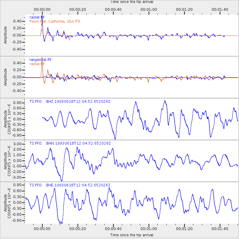
PFO Pinon Flat, California, USA - Earthquake Result Viewer
*The percent match for this event was below the threshold and hence no stack was calculated.
| Earthquake location: |
Kermadec Islands Region |
| Earthquake latitude/longitude: |
-29.4/-176.7 |
| Earthquake time(UTC): |
1993/06/18 (169) 11:52:51 GMT |
| Earthquake Depth: |
21 km |
| Earthquake Magnitude: |
6.2 MB, 6.8 MS, 6.9 UNKNOWN, 6.8 MW |
| Earthquake Catalog/Contributor: |
WHDF/NEIC |
|
| Network: |
TS TERRAscope (Southern California Seismic Network) |
| Station: |
PFO Pinon Flat, California, USA |
| Lat/Lon: |
33.61 N/116.46 W |
| Elevation: |
1280 m |
|
| Distance: |
84.7 deg |
| Az: |
46.71 deg |
| Baz: |
229.567 deg |
| Ray Param: |
$rayparam |
*The percent match for this event was below the threshold and hence was not used in the summary stack. |
|
| Radial Match: |
78.30053 % |
| Radial Bump: |
369 |
| Transverse Match: |
72.07554 % |
| Transverse Bump: |
400 |
| SOD ConfigId: |
4480 |
| Insert Time: |
2010-02-26 14:44:15.201 +0000 |
| GWidth: |
2.5 |
| Max Bumps: |
400 |
| Tol: |
0.001 |
|
Signal To Noise
| Channel | StoN | STA | LTA |
| TS:PFO: :BHN:19930618T12:04:52.652026Z | 1.5053452 | 9.859633E-7 | 6.549749E-7 |
| TS:PFO: :BHE:19930618T12:04:52.652026Z | 1.0863639 | 3.0357475E-7 | 2.794411E-7 |
| TS:PFO: :BHZ:19930618T12:04:52.652026Z | 1.6979028 | 3.6663596E-7 | 2.159346E-7 |
| Arrivals |
| Ps | |
| PpPs | |
| PsPs/PpSs | |


