You are here: Home > Network List > AV - Alaska Volcano Observatory Stations List
> Station STLK Strandline Lake, Regional Station, Alaska > Earthquake Result Viewer
STLK Strandline Lake, Regional Station, Alaska - Earthquake Result Viewer
| Earthquake location: |
Samoa Islands Region |
| Earthquake latitude/longitude: |
-16.0/-172.2 |
| Earthquake time(UTC): |
2020/03/17 (077) 16:06:22 GMT |
| Earthquake Depth: |
10 km |
| Earthquake Magnitude: |
6.0 mww |
| Earthquake Catalog/Contributor: |
NEIC PDE/us |
|
| Network: |
AV Alaska Volcano Observatory |
| Station: |
STLK Strandline Lake, Regional Station, Alaska |
| Lat/Lon: |
61.50 N/151.83 W |
| Elevation: |
945 m |
|
| Distance: |
78.9 deg |
| Az: |
9.788 deg |
| Baz: |
199.927 deg |
| Ray Param: |
0.04929847 |
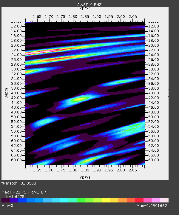
| Estimated Moho Depth: |
22.75 km |
| Estimated Crust Vp/Vs: |
1.65 |
| Assumed Crust Vp: |
6.302 km/s |
| Estimated Crust Vs: |
3.825 km/s |
| Estimated Crust Poisson's Ratio: |
0.21 |
|
| Radial Match: |
81.0508 % |
| Radial Bump: |
400 |
| Transverse Match: |
69.32127 % |
| Transverse Bump: |
400 |
| SOD ConfigId: |
20906531 |
| Insert Time: |
2020-04-08 11:16:31.173 +0000 |
| GWidth: |
2.5 |
| Max Bumps: |
400 |
| Tol: |
0.001 |
|
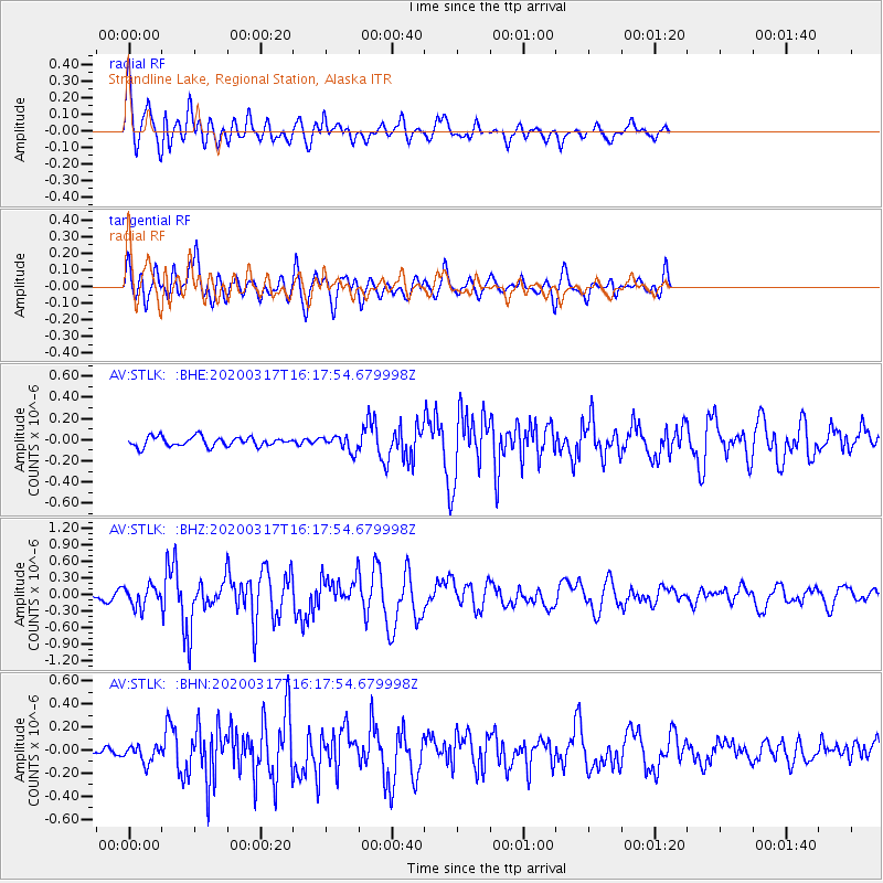
Signal To Noise
| Channel | StoN | STA | LTA |
| AV:STLK: :BHZ:20200317T16:17:54.679998Z | 2.20181 | 1.8473509E-7 | 8.390147E-8 |
| AV:STLK: :BHN:20200317T16:17:54.679998Z | 1.0945773 | 7.405491E-8 | 6.7656174E-8 |
| AV:STLK: :BHE:20200317T16:17:54.679998Z | 1.594558 | 7.149376E-8 | 4.4836096E-8 |
| Arrivals |
| Ps | 2.4 SECOND |
| PpPs | 9.3 SECOND |
| PsPs/PpSs | 12 SECOND |


