You are here: Home > Network List > XL97 - Deep Probe (Archean-Proterozoic) Stations List
> Station S102 Oregon Trail, WY > Earthquake Result Viewer
S102 Oregon Trail, WY - Earthquake Result Viewer
| Earthquake location: |
Tonga Islands |
| Earthquake latitude/longitude: |
-15.2/-173.3 |
| Earthquake time(UTC): |
1997/05/27 (147) 08:00:29 GMT |
| Earthquake Depth: |
14 km |
| Earthquake Magnitude: |
5.6 MB, 6.3 MS, 6.4 UNKNOWN, 5.7 ME |
| Earthquake Catalog/Contributor: |
WHDF/NEIC |
|
| Network: |
XL Deep Probe (Archean-Proterozoic) |
| Station: |
S102 Oregon Trail, WY |
| Lat/Lon: |
42.34 N/108.94 W |
| Elevation: |
2212 m |
|
| Distance: |
82.3 deg |
| Az: |
42.428 deg |
| Baz: |
241.467 deg |
| Ray Param: |
0.046990573 |
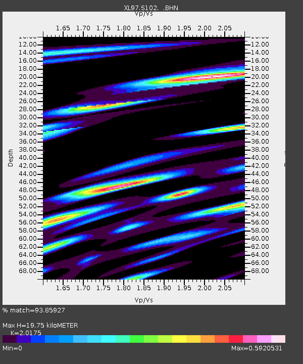
| Estimated Moho Depth: |
19.75 km |
| Estimated Crust Vp/Vs: |
2.02 |
| Assumed Crust Vp: |
6.161 km/s |
| Estimated Crust Vs: |
3.054 km/s |
| Estimated Crust Poisson's Ratio: |
0.34 |
|
| Radial Match: |
93.85927 % |
| Radial Bump: |
400 |
| Transverse Match: |
93.906364 % |
| Transverse Bump: |
400 |
| SOD ConfigId: |
6273 |
| Insert Time: |
2010-03-08 18:17:38.969 +0000 |
| GWidth: |
2.5 |
| Max Bumps: |
400 |
| Tol: |
0.001 |
|
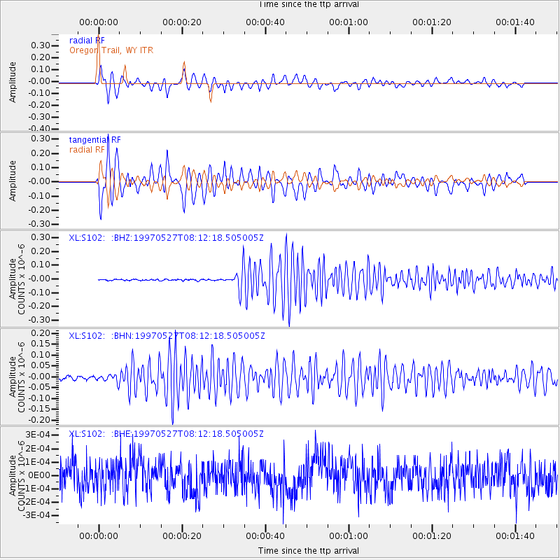
Signal To Noise
| Channel | StoN | STA | LTA |
| XL:S102: :BHN:19970527T08:12:18.505005Z | 2.3963614 | 1.651243E-8 | 6.8906267E-9 |
| XL:S102: :BHE:19970527T08:12:18.505005Z | 1.0022894 | 1.00958984E-10 | 1.0072837E-10 |
| XL:S102: :BHZ:19970527T08:12:18.505005Z | 16.57145 | 7.056513E-8 | 4.258235E-9 |
| Arrivals |
| Ps | 3.3 SECOND |
| PpPs | 9.5 SECOND |
| PsPs/PpSs | 13 SECOND |


