You are here: Home > Network List > XL97 - Deep Probe (Archean-Proterozoic) Stations List
> Station S102 Oregon Trail, WY > Earthquake Result Viewer
S102 Oregon Trail, WY - Earthquake Result Viewer
| Earthquake location: |
Southern Pacific Ocean |
| Earthquake latitude/longitude: |
-36.0/-102.5 |
| Earthquake time(UTC): |
1997/05/29 (149) 17:02:38 GMT |
| Earthquake Depth: |
10 km |
| Earthquake Magnitude: |
5.6 MB, 6.1 MS, 6.5 UNKNOWN, 6.4 MW |
| Earthquake Catalog/Contributor: |
WHDF/NEIC |
|
| Network: |
XL Deep Probe (Archean-Proterozoic) |
| Station: |
S102 Oregon Trail, WY |
| Lat/Lon: |
42.34 N/108.94 W |
| Elevation: |
2212 m |
|
| Distance: |
78.2 deg |
| Az: |
355.137 deg |
| Baz: |
174.678 deg |
| Ray Param: |
0.049834713 |
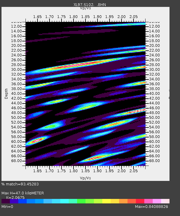
| Estimated Moho Depth: |
47.0 km |
| Estimated Crust Vp/Vs: |
2.07 |
| Assumed Crust Vp: |
6.161 km/s |
| Estimated Crust Vs: |
2.98 km/s |
| Estimated Crust Poisson's Ratio: |
0.35 |
|
| Radial Match: |
93.45283 % |
| Radial Bump: |
400 |
| Transverse Match: |
93.369606 % |
| Transverse Bump: |
400 |
| SOD ConfigId: |
6273 |
| Insert Time: |
2010-03-08 18:17:39.884 +0000 |
| GWidth: |
2.5 |
| Max Bumps: |
400 |
| Tol: |
0.001 |
|
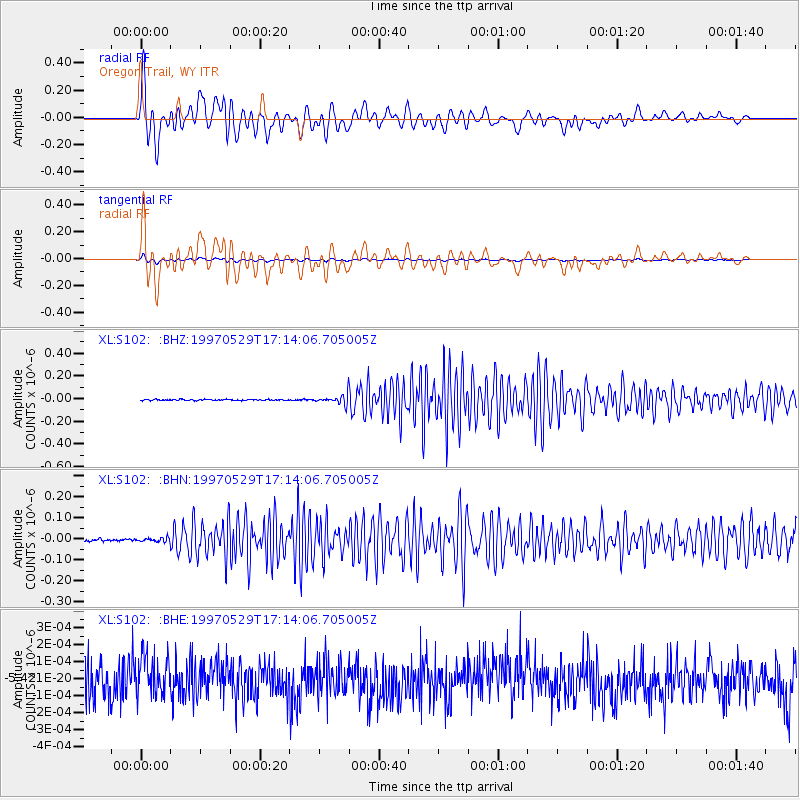
Signal To Noise
| Channel | StoN | STA | LTA |
| XL:S102: :BHN:19970529T17:14:06.705005Z | 1.770458 | 9.766091E-9 | 5.5161378E-9 |
| XL:S102: :BHE:19970529T17:14:06.705005Z | 1.1977521 | 1.1791747E-10 | 9.844898E-11 |
| XL:S102: :BHZ:19970529T17:14:06.705005Z | 6.7288327 | 3.166864E-8 | 4.7064095E-9 |
| Arrivals |
| Ps | 8.3 SECOND |
| PpPs | 23 SECOND |
| PsPs/PpSs | 31 SECOND |


