You are here: Home > Network List > CN - Canadian National Seismograph Network Stations List
> Station INK INUVIK, NT > Earthquake Result Viewer
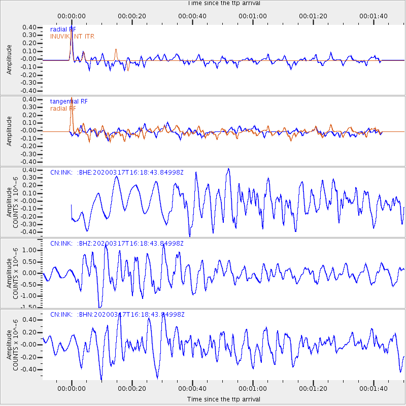
INK INUVIK, NT - Earthquake Result Viewer
*The percent match for this event was below the threshold and hence no stack was calculated.
| Earthquake location: |
Samoa Islands Region |
| Earthquake latitude/longitude: |
-16.0/-172.2 |
| Earthquake time(UTC): |
2020/03/17 (077) 16:06:22 GMT |
| Earthquake Depth: |
10 km |
| Earthquake Magnitude: |
6.0 mww |
| Earthquake Catalog/Contributor: |
NEIC PDE/us |
|
| Network: |
CN Canadian National Seismograph Network |
| Station: |
INK INUVIK, NT |
| Lat/Lon: |
68.31 N/133.53 W |
| Elevation: |
44 m |
|
| Distance: |
88.6 deg |
| Az: |
13.436 deg |
| Baz: |
216.94 deg |
| Ray Param: |
$rayparam |
*The percent match for this event was below the threshold and hence was not used in the summary stack. |
|
| Radial Match: |
77.27833 % |
| Radial Bump: |
400 |
| Transverse Match: |
46.30135 % |
| Transverse Bump: |
400 |
| SOD ConfigId: |
20906531 |
| Insert Time: |
2020-04-08 11:20:22.424 +0000 |
| GWidth: |
2.5 |
| Max Bumps: |
400 |
| Tol: |
0.001 |
|
Signal To Noise
| Channel | StoN | STA | LTA |
| CN:INK: :BHZ:20200317T16:18:43.84998Z | 2.7997277 | 4.4923894E-7 | 1.6045807E-7 |
| CN:INK: :BHN:20200317T16:18:43.84998Z | 1.5239 | 1.7378953E-7 | 1.1404261E-7 |
| CN:INK: :BHE:20200317T16:18:43.84998Z | 0.9814875 | 1.750513E-7 | 1.7835306E-7 |
| Arrivals |
| Ps | |
| PpPs | |
| PsPs/PpSs | |


