You are here: Home > Network List > GS - US Geological Survey Networks Stations List
> Station ALQ2 ASL Reference, STS-6 > Earthquake Result Viewer
ALQ2 ASL Reference, STS-6 - Earthquake Result Viewer
| Earthquake location: |
Samoa Islands Region |
| Earthquake latitude/longitude: |
-16.0/-172.2 |
| Earthquake time(UTC): |
2020/03/17 (077) 16:06:22 GMT |
| Earthquake Depth: |
10 km |
| Earthquake Magnitude: |
6.0 mww |
| Earthquake Catalog/Contributor: |
NEIC PDE/us |
|
| Network: |
GS US Geological Survey Networks |
| Station: |
ALQ2 ASL Reference, STS-6 |
| Lat/Lon: |
34.94 N/106.46 W |
| Elevation: |
1854 m |
|
| Distance: |
80.3 deg |
| Az: |
49.444 deg |
| Baz: |
242.79 deg |
| Ray Param: |
0.048366185 |
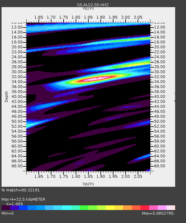
| Estimated Moho Depth: |
32.5 km |
| Estimated Crust Vp/Vs: |
1.88 |
| Assumed Crust Vp: |
6.502 km/s |
| Estimated Crust Vs: |
3.449 km/s |
| Estimated Crust Poisson's Ratio: |
0.30 |
|
| Radial Match: |
80.32191 % |
| Radial Bump: |
400 |
| Transverse Match: |
58.000664 % |
| Transverse Bump: |
400 |
| SOD ConfigId: |
20906531 |
| Insert Time: |
2020-04-08 11:21:44.307 +0000 |
| GWidth: |
2.5 |
| Max Bumps: |
400 |
| Tol: |
0.001 |
|

Signal To Noise
| Channel | StoN | STA | LTA |
| GS:ALQ2:00:HHZ:20200317T16:18:02.067998Z | 2.291497 | 2.8802253E-7 | 1.2569187E-7 |
| GS:ALQ2:00:HH1:20200317T16:18:02.067998Z | 1.39847 | 1.5166525E-7 | 1.0845084E-7 |
| GS:ALQ2:00:HH2:20200317T16:18:02.067998Z | 0.5882252 | 8.9990564E-8 | 1.5298657E-7 |
| Arrivals |
| Ps | 4.5 SECOND |
| PpPs | 14 SECOND |
| PsPs/PpSs | 19 SECOND |


