You are here: Home > Network List > XL97 - Deep Probe (Archean-Proterozoic) Stations List
> Station S102 Oregon Trail, WY > Earthquake Result Viewer
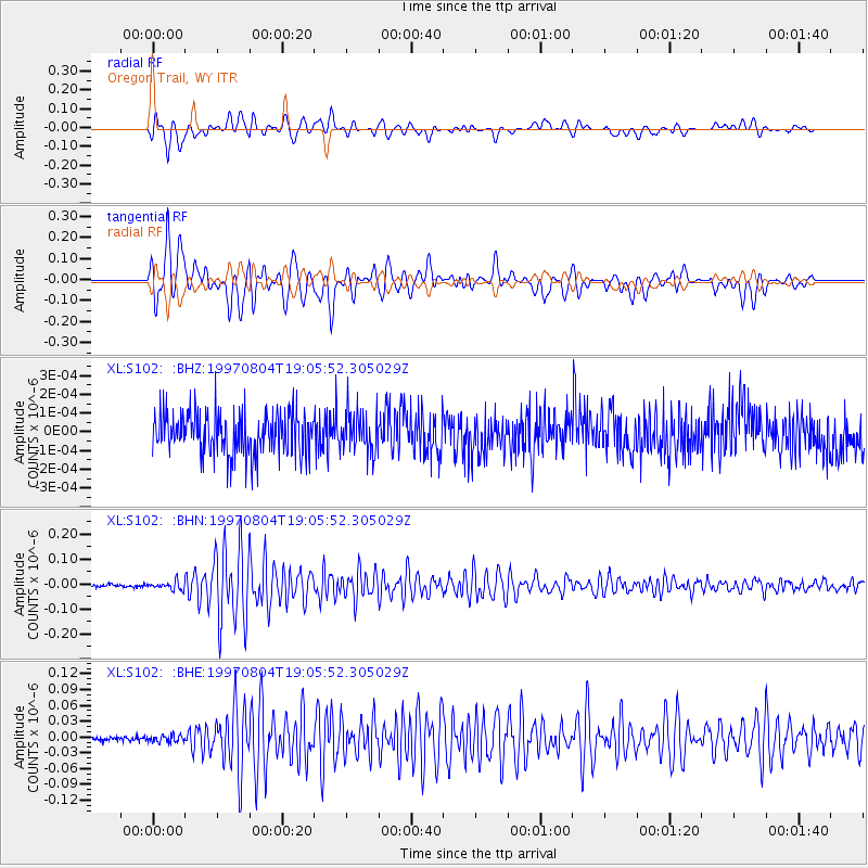
S102 Oregon Trail, WY - Earthquake Result Viewer
*The percent match for this event was below the threshold and hence no stack was calculated.
| Earthquake location: |
Tonga Islands |
| Earthquake latitude/longitude: |
-15.2/-175.3 |
| Earthquake time(UTC): |
1997/08/04 (216) 18:53:58 GMT |
| Earthquake Depth: |
33 km |
| Earthquake Magnitude: |
5.5 MB, 6.0 MS, 6.1 UNKNOWN, 6.0 MW |
| Earthquake Catalog/Contributor: |
WHDF/NEIC |
|
| Network: |
XL Deep Probe (Archean-Proterozoic) |
| Station: |
S102 Oregon Trail, WY |
| Lat/Lon: |
42.34 N/108.94 W |
| Elevation: |
2212 m |
|
| Distance: |
83.5 deg |
| Az: |
43.11 deg |
| Baz: |
242.891 deg |
| Ray Param: |
$rayparam |
*The percent match for this event was below the threshold and hence was not used in the summary stack. |
|
| Radial Match: |
90.37027 % |
| Radial Bump: |
400 |
| Transverse Match: |
90.3837 % |
| Transverse Bump: |
400 |
| SOD ConfigId: |
4480 |
| Insert Time: |
2010-03-08 18:17:53.230 +0000 |
| GWidth: |
2.5 |
| Max Bumps: |
400 |
| Tol: |
0.001 |
|
Signal To Noise
| Channel | StoN | STA | LTA |
| XL:S102: :BHN:19970804T19:05:52.305029Z | 2.9908895 | 1.5644325E-8 | 5.23066E-9 |
| XL:S102: :BHE:19970804T19:05:52.305029Z | 1.3441584 | 6.1721455E-9 | 4.591829E-9 |
| XL:S102: :BHZ:19970804T19:05:52.305029Z | 0.93748236 | 1.0603109E-10 | 1.1310196E-10 |
| Arrivals |
| Ps | |
| PpPs | |
| PsPs/PpSs | |


