You are here: Home > Network List > US - United States National Seismic Network Stations List
> Station WMOK Wichita Mountains, Oklahoma, USA > Earthquake Result Viewer
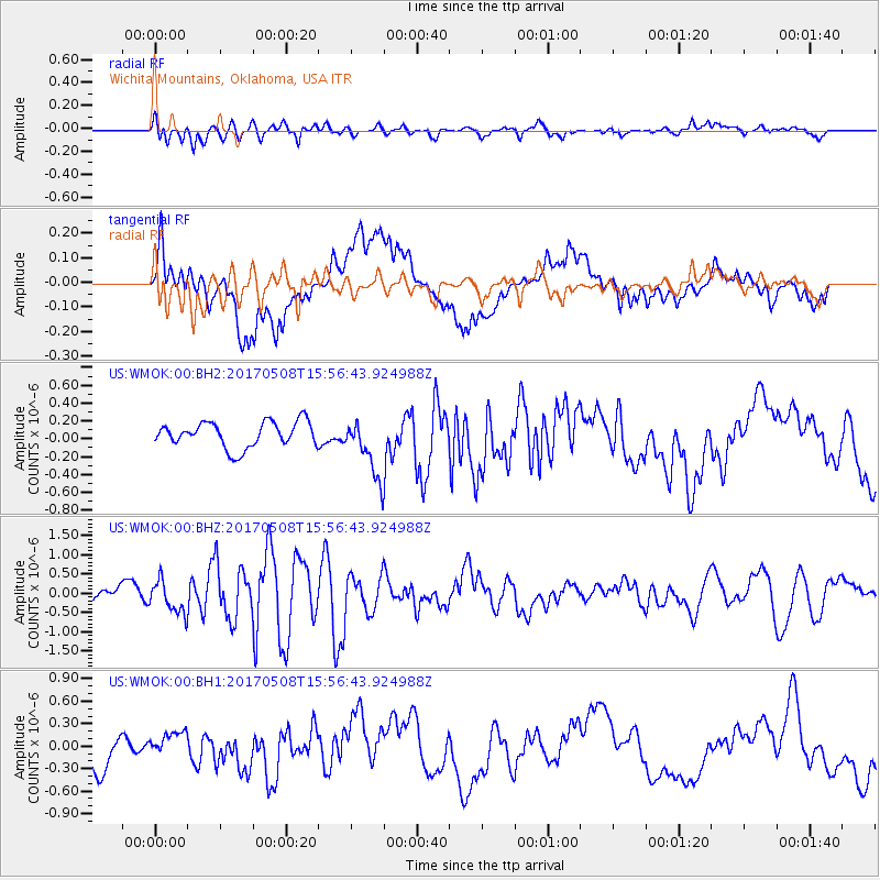
WMOK Wichita Mountains, Oklahoma, USA - Earthquake Result Viewer
*The percent match for this event was below the threshold and hence no stack was calculated.
| Earthquake location: |
Andreanof Islands, Aleutian Is. |
| Earthquake latitude/longitude: |
51.0/-177.1 |
| Earthquake time(UTC): |
2017/05/08 (128) 15:47:28 GMT |
| Earthquake Depth: |
1.0 km |
| Earthquake Magnitude: |
5.7 Mi |
| Earthquake Catalog/Contributor: |
NEIC PDE/at |
|
| Network: |
US United States National Seismic Network |
| Station: |
WMOK Wichita Mountains, Oklahoma, USA |
| Lat/Lon: |
34.74 N/98.78 W |
| Elevation: |
486 m |
|
| Distance: |
57.0 deg |
| Az: |
74.122 deg |
| Baz: |
312.38 deg |
| Ray Param: |
$rayparam |
*The percent match for this event was below the threshold and hence was not used in the summary stack. |
|
| Radial Match: |
46.667103 % |
| Radial Bump: |
400 |
| Transverse Match: |
65.44307 % |
| Transverse Bump: |
400 |
| SOD ConfigId: |
2028011 |
| Insert Time: |
2017-05-22 15:55:39.884 +0000 |
| GWidth: |
2.5 |
| Max Bumps: |
400 |
| Tol: |
0.001 |
|
Signal To Noise
| Channel | StoN | STA | LTA |
| US:WMOK:00:BHZ:20170508T15:56:43.924988Z | 2.6127372 | 4.15155E-7 | 1.5889657E-7 |
| US:WMOK:00:BH1:20170508T15:56:43.924988Z | 0.7640821 | 1.6281766E-7 | 2.1308922E-7 |
| US:WMOK:00:BH2:20170508T15:56:43.924988Z | 2.3428872 | 3.3312259E-7 | 1.4218465E-7 |
| Arrivals |
| Ps | |
| PpPs | |
| PsPs/PpSs | |


