You are here: Home > Network List > XL97 - Deep Probe (Archean-Proterozoic) Stations List
> Station S103 Oregon Butte, WY > Earthquake Result Viewer
S103 Oregon Butte, WY - Earthquake Result Viewer
| Earthquake location: |
Tonga Islands |
| Earthquake latitude/longitude: |
-15.2/-173.3 |
| Earthquake time(UTC): |
1997/05/27 (147) 08:00:29 GMT |
| Earthquake Depth: |
14 km |
| Earthquake Magnitude: |
5.6 MB, 6.3 MS, 6.4 UNKNOWN, 5.7 ME |
| Earthquake Catalog/Contributor: |
WHDF/NEIC |
|
| Network: |
XL Deep Probe (Archean-Proterozoic) |
| Station: |
S103 Oregon Butte, WY |
| Lat/Lon: |
42.27 N/108.85 W |
| Elevation: |
2408 m |
|
| Distance: |
82.3 deg |
| Az: |
42.525 deg |
| Baz: |
241.536 deg |
| Ray Param: |
0.04697781 |
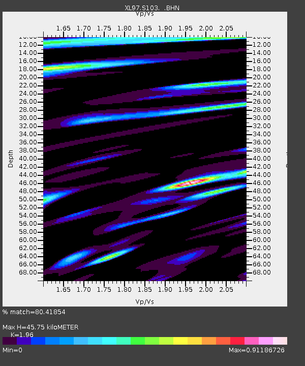
| Estimated Moho Depth: |
45.75 km |
| Estimated Crust Vp/Vs: |
1.96 |
| Assumed Crust Vp: |
6.161 km/s |
| Estimated Crust Vs: |
3.143 km/s |
| Estimated Crust Poisson's Ratio: |
0.32 |
|
| Radial Match: |
80.41854 % |
| Radial Bump: |
400 |
| Transverse Match: |
89.82205 % |
| Transverse Bump: |
400 |
| SOD ConfigId: |
6273 |
| Insert Time: |
2010-03-08 18:17:56.094 +0000 |
| GWidth: |
2.5 |
| Max Bumps: |
400 |
| Tol: |
0.001 |
|

Signal To Noise
| Channel | StoN | STA | LTA |
| XL:S103: :BHN:19970527T08:12:18.606018Z | 1.1826783 | 9.864466E-9 | 8.340785E-9 |
| XL:S103: :BHE:19970527T08:12:18.606018Z | 1.6906948 | 1.2794015E-8 | 7.567312E-9 |
| XL:S103: :BHZ:19970527T08:12:18.606018Z | 13.042784 | 6.0572646E-8 | 4.64415E-9 |
| Arrivals |
| Ps | 7.3 SECOND |
| PpPs | 22 SECOND |
| PsPs/PpSs | 29 SECOND |


