You are here: Home > Network List > XL97 - Deep Probe (Archean-Proterozoic) Stations List
> Station S103 Oregon Butte, WY > Earthquake Result Viewer
S103 Oregon Butte, WY - Earthquake Result Viewer
| Earthquake location: |
Southern Pacific Ocean |
| Earthquake latitude/longitude: |
-36.0/-102.5 |
| Earthquake time(UTC): |
1997/05/29 (149) 17:02:38 GMT |
| Earthquake Depth: |
10 km |
| Earthquake Magnitude: |
5.6 MB, 6.1 MS, 6.5 UNKNOWN, 6.4 MW |
| Earthquake Catalog/Contributor: |
WHDF/NEIC |
|
| Network: |
XL Deep Probe (Archean-Proterozoic) |
| Station: |
S103 Oregon Butte, WY |
| Lat/Lon: |
42.27 N/108.85 W |
| Elevation: |
2408 m |
|
| Distance: |
78.1 deg |
| Az: |
355.193 deg |
| Baz: |
174.745 deg |
| Ray Param: |
0.049889952 |
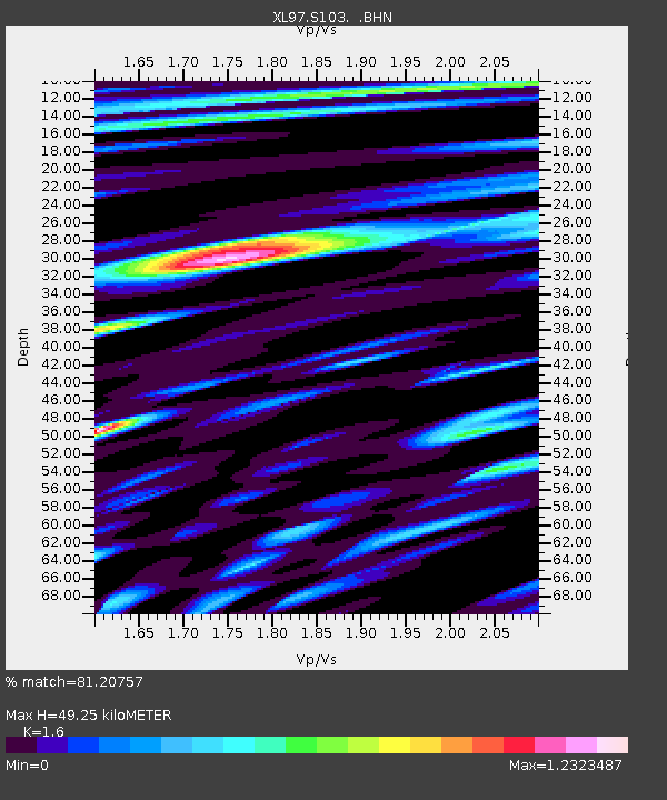
| Estimated Moho Depth: |
49.25 km |
| Estimated Crust Vp/Vs: |
1.60 |
| Assumed Crust Vp: |
6.161 km/s |
| Estimated Crust Vs: |
3.851 km/s |
| Estimated Crust Poisson's Ratio: |
0.18 |
|
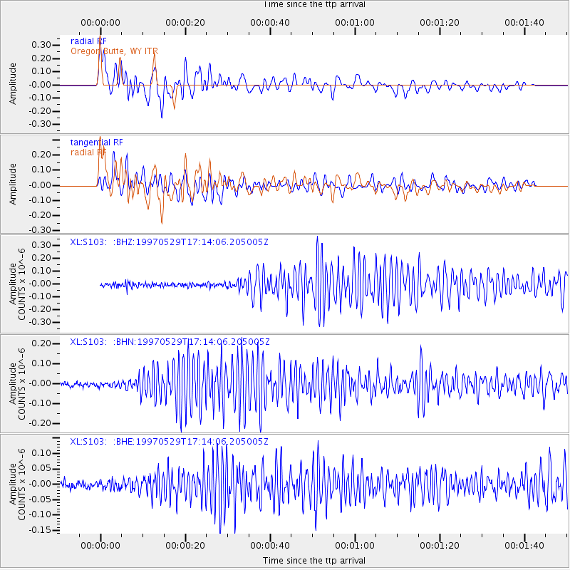
| Radial Match: |
81.20757 % |
| Radial Bump: |
400 |
| Transverse Match: |
79.32446 % |
| Transverse Bump: |
400 |
| SOD ConfigId: |
6273 |
| Insert Time: |
2010-03-08 18:17:57.180 +0000 |
| GWidth: |
2.5 |
| Max Bumps: |
400 |
| Tol: |
0.001 |
|
Signal To Noise
| Channel | StoN | STA | LTA |
| XL:S103: :BHN:19970529T17:14:06.205005Z | 1.1894841 | 9.51328E-9 | 7.99782E-9 |
| XL:S103: :BHE:19970529T17:14:06.205005Z | 1.3018503 | 1.2736736E-8 | 9.783564E-9 |
| XL:S103: :BHZ:19970529T17:14:06.205005Z | 2.1947927 | 3.0061365E-8 | 1.3696676E-8 |
| Arrivals |
| Ps | 4.9 SECOND |
| PpPs | 20 SECOND |
| PsPs/PpSs | 25 SECOND |


