You are here: Home > Network List > XL97 - Deep Probe (Archean-Proterozoic) Stations List
> Station S103 Oregon Butte, WY > Earthquake Result Viewer
S103 Oregon Butte, WY - Earthquake Result Viewer

| Earthquake location: |
Tonga Islands |
| Earthquake latitude/longitude: |
-15.2/-175.3 |
| Earthquake time(UTC): |
1997/08/04 (216) 18:53:58 GMT |
| Earthquake Depth: |
33 km |
| Earthquake Magnitude: |
5.5 MB, 6.0 MS, 6.1 UNKNOWN, 6.0 MW |
| Earthquake Catalog/Contributor: |
WHDF/NEIC |
|
| Network: |
XL Deep Probe (Archean-Proterozoic) |
| Station: |
S103 Oregon Butte, WY |
| Lat/Lon: |
42.27 N/108.85 W |
| Elevation: |
2408 m |
|
| Distance: |
83.5 deg |
| Az: |
43.207 deg |
| Baz: |
242.958 deg |
| Ray Param: |
0.046073675 |
| Estimated Moho Depth: |
26.0 km |
| Estimated Crust Vp/Vs: |
2.10 |
| Assumed Crust Vp: |
6.161 km/s |
| Estimated Crust Vs: |
2.937 km/s |
| Estimated Crust Poisson's Ratio: |
0.35 |
|
| Radial Match: |
89.12074 % |
| Radial Bump: |
400 |
| Transverse Match: |
88.63252 % |
| Transverse Bump: |
400 |
| SOD ConfigId: |
6273 |
| Insert Time: |
2010-03-08 18:17:58.806 +0000 |
| GWidth: |
2.5 |
| Max Bumps: |
400 |
| Tol: |
0.001 |
|
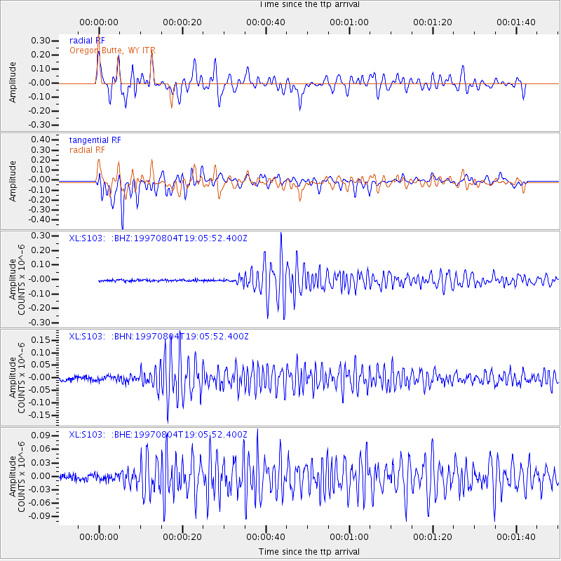
Signal To Noise
| Channel | StoN | STA | LTA |
| XL:S103: :BHN:19970804T19:05:52.400Z | 1.2193835 | 8.7532905E-9 | 7.1784556E-9 |
| XL:S103: :BHE:19970804T19:05:52.400Z | 1.0657128 | 6.163915E-9 | 5.7838423E-9 |
| XL:S103: :BHZ:19970804T19:05:52.400Z | 3.348856 | 1.7584403E-8 | 5.2508686E-9 |
| Arrivals |
| Ps | 4.7 SECOND |
| PpPs | 13 SECOND |
| PsPs/PpSs | 18 SECOND |


