You are here: Home > Network List > TA - USArray Transportable Network (new EarthScope stations) Stations List
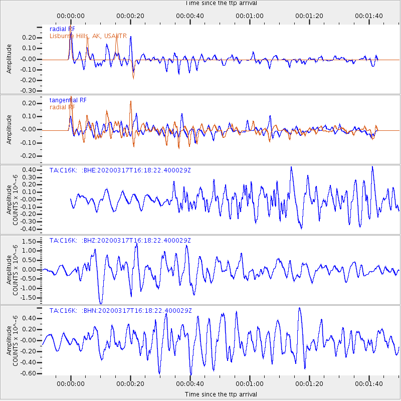
> Station C16K Lisburne Hills, AK, USA > Earthquake Result Viewer
C16K Lisburne Hills, AK, USA - Earthquake Result Viewer
| Earthquake location: |
Samoa Islands Region |
| Earthquake latitude/longitude: |
-16.0/-172.2 |
| Earthquake time(UTC): |
2020/03/17 (077) 16:06:22 GMT |
| Earthquake Depth: |
10 km |
| Earthquake Magnitude: |
6.0 mww |
| Earthquake Catalog/Contributor: |
NEIC PDE/us |
|
| Network: |
TA USArray Transportable Network (new EarthScope stations) |
| Station: |
C16K Lisburne Hills, AK, USA |
| Lat/Lon: |
68.27 N/165.34 W |
| Elevation: |
102 m |
|
| Distance: |
84.2 deg |
| Az: |
2.557 deg |
| Baz: |
186.617 deg |
| Ray Param: |
0.045642726 |
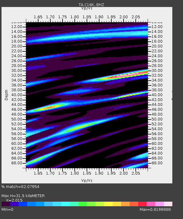
| Estimated Moho Depth: |
31.5 km |
| Estimated Crust Vp/Vs: |
2.02 |
| Assumed Crust Vp: |
5.906 km/s |
| Estimated Crust Vs: |
2.931 km/s |
| Estimated Crust Poisson's Ratio: |
0.34 |
|
| Radial Match: |
82.07954 % |
| Radial Bump: |
400 |
| Transverse Match: |
72.81695 % |
| Transverse Bump: |
400 |
| SOD ConfigId: |
20906531 |
| Insert Time: |
2020-04-08 11:28:06.184 +0000 |
| GWidth: |
2.5 |
| Max Bumps: |
400 |
| Tol: |
0.001 |
|
Signal To Noise
| Channel | StoN | STA | LTA |
| TA:C16K: :BHZ:20200317T16:18:22.400029Z | 3.2339277 | 2.398469E-7 | 7.4165825E-8 |
| TA:C16K: :BHN:20200317T16:18:22.400029Z | 1.0999008 | 8.120779E-8 | 7.383191E-8 |
| TA:C16K: :BHE:20200317T16:18:22.400029Z | 1.0760369 | 8.083754E-8 | 7.512524E-8 |
| Arrivals |
| Ps | 5.5 SECOND |
| PpPs | 16 SECOND |
| PsPs/PpSs | 21 SECOND |


