You are here: Home > Network List > TA - USArray Transportable Network (new EarthScope stations) Stations List
> Station D20K Etivluk River, AK, USA > Earthquake Result Viewer
D20K Etivluk River, AK, USA - Earthquake Result Viewer
| Earthquake location: |
Samoa Islands Region |
| Earthquake latitude/longitude: |
-16.0/-172.2 |
| Earthquake time(UTC): |
2020/03/17 (077) 16:06:22 GMT |
| Earthquake Depth: |
10 km |
| Earthquake Magnitude: |
6.0 mww |
| Earthquake Catalog/Contributor: |
NEIC PDE/us |
|
| Network: |
TA USArray Transportable Network (new EarthScope stations) |
| Station: |
D20K Etivluk River, AK, USA |
| Lat/Lon: |
68.71 N/156.61 W |
| Elevation: |
577 m |
|
| Distance: |
85.2 deg |
| Az: |
5.647 deg |
| Baz: |
195.019 deg |
| Ray Param: |
0.044903025 |
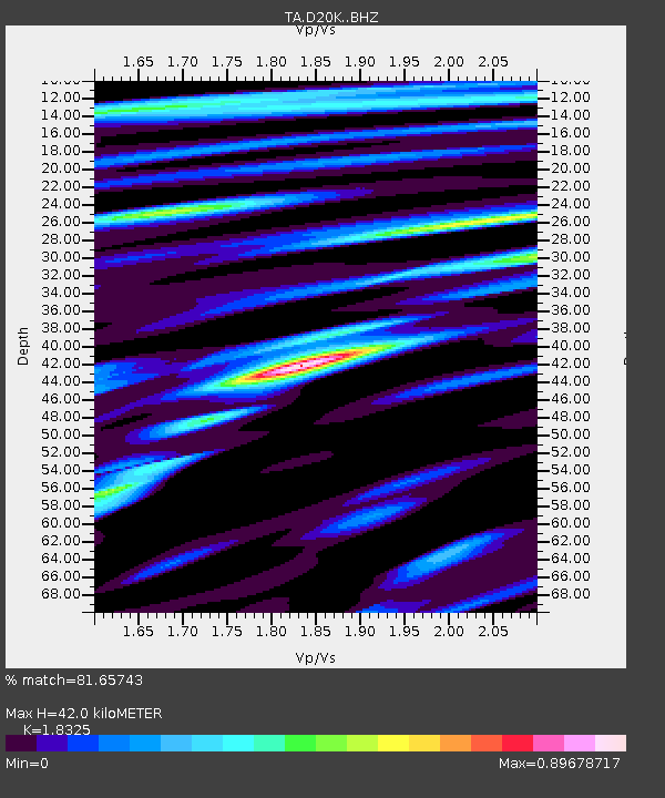
| Estimated Moho Depth: |
42.0 km |
| Estimated Crust Vp/Vs: |
1.83 |
| Assumed Crust Vp: |
6.221 km/s |
| Estimated Crust Vs: |
3.395 km/s |
| Estimated Crust Poisson's Ratio: |
0.29 |
|
| Radial Match: |
81.65743 % |
| Radial Bump: |
400 |
| Transverse Match: |
79.361725 % |
| Transverse Bump: |
400 |
| SOD ConfigId: |
20906531 |
| Insert Time: |
2020-04-08 11:28:17.647 +0000 |
| GWidth: |
2.5 |
| Max Bumps: |
400 |
| Tol: |
0.001 |
|

Signal To Noise
| Channel | StoN | STA | LTA |
| TA:D20K: :BHZ:20200317T16:18:27.59998Z | 3.6686954 | 4.317676E-7 | 1.1768968E-7 |
| TA:D20K: :BHN:20200317T16:18:27.59998Z | 1.0493741 | 1.2032625E-7 | 1.1466478E-7 |
| TA:D20K: :BHE:20200317T16:18:27.59998Z | 0.74200696 | 8.945643E-8 | 1.205601E-7 |
| Arrivals |
| Ps | 5.7 SECOND |
| PpPs | 19 SECOND |
| PsPs/PpSs | 24 SECOND |


