You are here: Home > Network List > TA - USArray Transportable Network (new EarthScope stations) Stations List
> Station E28M Babbage River, YT, CAN > Earthquake Result Viewer
E28M Babbage River, YT, CAN - Earthquake Result Viewer
| Earthquake location: |
Samoa Islands Region |
| Earthquake latitude/longitude: |
-16.0/-172.2 |
| Earthquake time(UTC): |
2020/03/17 (077) 16:06:22 GMT |
| Earthquake Depth: |
10 km |
| Earthquake Magnitude: |
6.0 mww |
| Earthquake Catalog/Contributor: |
NEIC PDE/us |
|
| Network: |
TA USArray Transportable Network (new EarthScope stations) |
| Station: |
E28M Babbage River, YT, CAN |
| Lat/Lon: |
68.60 N/139.53 W |
| Elevation: |
474 m |
|
| Distance: |
87.6 deg |
| Az: |
11.43 deg |
| Baz: |
211.288 deg |
| Ray Param: |
0.043209255 |
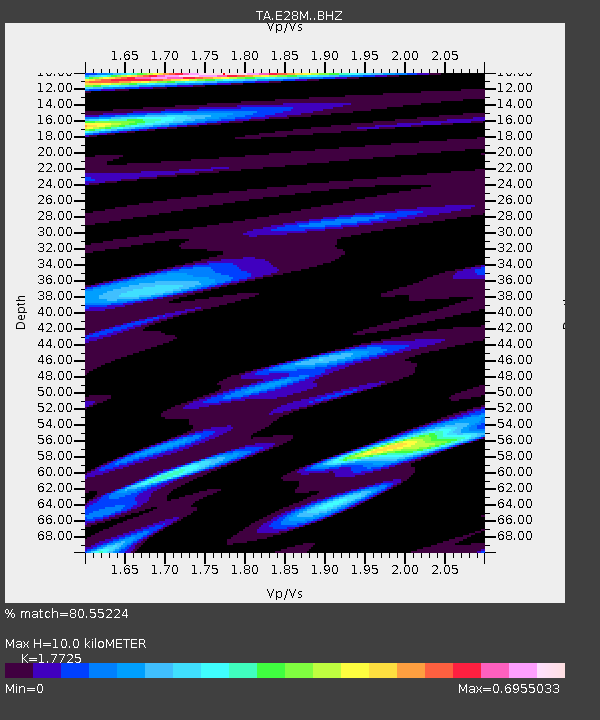
| Estimated Moho Depth: |
10.0 km |
| Estimated Crust Vp/Vs: |
1.77 |
| Assumed Crust Vp: |
6.316 km/s |
| Estimated Crust Vs: |
3.563 km/s |
| Estimated Crust Poisson's Ratio: |
0.27 |
|
| Radial Match: |
80.55224 % |
| Radial Bump: |
400 |
| Transverse Match: |
82.81626 % |
| Transverse Bump: |
400 |
| SOD ConfigId: |
20906531 |
| Insert Time: |
2020-04-08 11:28:33.156 +0000 |
| GWidth: |
2.5 |
| Max Bumps: |
400 |
| Tol: |
0.001 |
|

Signal To Noise
| Channel | StoN | STA | LTA |
| TA:E28M: :BHZ:20200317T16:18:39.125005Z | 2.2435033 | 2.8116253E-7 | 1.25323E-7 |
| TA:E28M: :BHN:20200317T16:18:39.125005Z | 1.1412379 | 9.290973E-8 | 8.1411365E-8 |
| TA:E28M: :BHE:20200317T16:18:39.125005Z | 1.0221206 | 6.793962E-8 | 6.6469276E-8 |
| Arrivals |
| Ps | 1.2 SECOND |
| PpPs | 4.3 SECOND |
| PsPs/PpSs | 5.5 SECOND |


