You are here: Home > Network List > TA - USArray Transportable Network (new EarthScope stations) Stations List
> Station G30M túh Zraii Njik, YT, CAN > Earthquake Result Viewer
G30M túh Zraii Njik, YT, CAN - Earthquake Result Viewer
| Earthquake location: |
Samoa Islands Region |
| Earthquake latitude/longitude: |
-16.0/-172.2 |
| Earthquake time(UTC): |
2020/03/17 (077) 16:06:22 GMT |
| Earthquake Depth: |
10 km |
| Earthquake Magnitude: |
6.0 mww |
| Earthquake Catalog/Contributor: |
NEIC PDE/us |
|
| Network: |
TA USArray Transportable Network (new EarthScope stations) |
| Station: |
G30M túh Zraii Njik, YT, CAN |
| Lat/Lon: |
66.98 N/136.22 W |
| Elevation: |
739 m |
|
| Distance: |
86.9 deg |
| Az: |
13.375 deg |
| Baz: |
214.447 deg |
| Ray Param: |
0.043707103 |
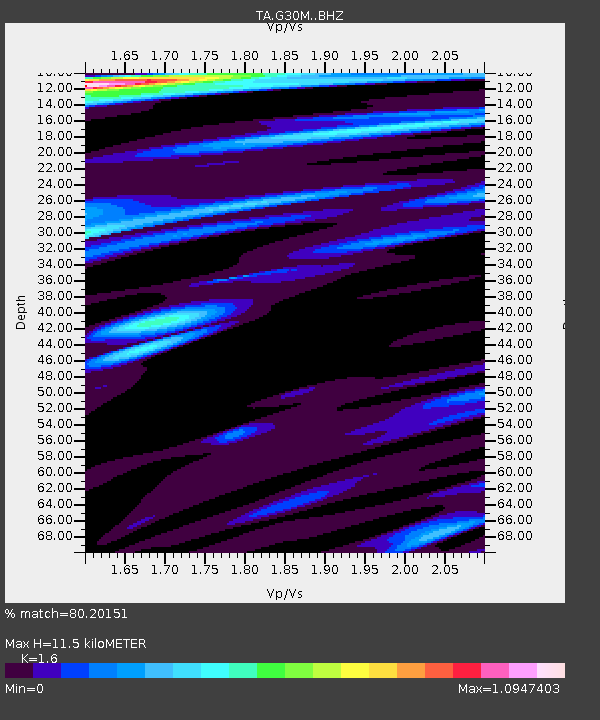
| Estimated Moho Depth: |
11.5 km |
| Estimated Crust Vp/Vs: |
1.60 |
| Assumed Crust Vp: |
6.522 km/s |
| Estimated Crust Vs: |
4.076 km/s |
| Estimated Crust Poisson's Ratio: |
0.18 |
|
| Radial Match: |
80.20151 % |
| Radial Bump: |
400 |
| Transverse Match: |
82.57273 % |
| Transverse Bump: |
400 |
| SOD ConfigId: |
20906531 |
| Insert Time: |
2020-04-08 11:29:03.360 +0000 |
| GWidth: |
2.5 |
| Max Bumps: |
400 |
| Tol: |
0.001 |
|

Signal To Noise
| Channel | StoN | STA | LTA |
| TA:G30M: :BHZ:20200317T16:18:35.799993Z | 3.346102 | 5.5435845E-7 | 1.6567292E-7 |
| TA:G30M: :BHN:20200317T16:18:35.799993Z | 2.0144758 | 2.1604859E-7 | 1.0724804E-7 |
| TA:G30M: :BHE:20200317T16:18:35.799993Z | 1.890952 | 1.3777066E-7 | 7.285783E-8 |
| Arrivals |
| Ps | 1.1 SECOND |
| PpPs | 4.5 SECOND |
| PsPs/PpSs | 5.6 SECOND |


