You are here: Home > Network List > TA - USArray Transportable Network (new EarthScope stations) Stations List
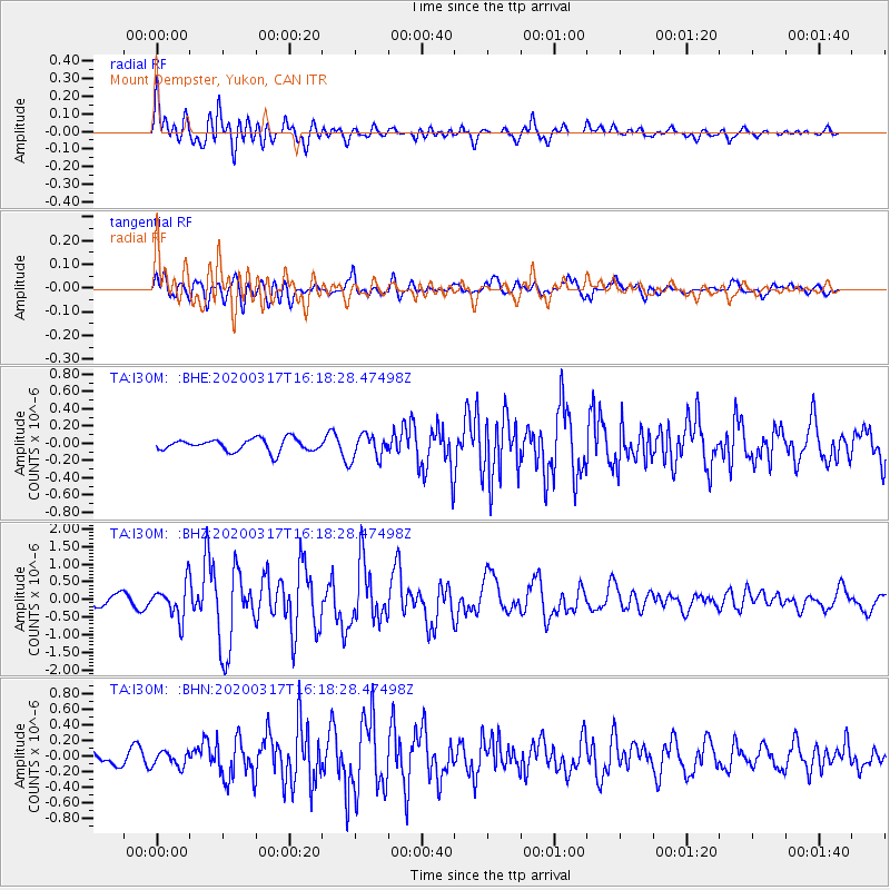
> Station I30M Mount Dempster, Yukon, CAN > Earthquake Result Viewer
I30M Mount Dempster, Yukon, CAN - Earthquake Result Viewer
| Earthquake location: |
Samoa Islands Region |
| Earthquake latitude/longitude: |
-16.0/-172.2 |
| Earthquake time(UTC): |
2020/03/17 (077) 16:06:22 GMT |
| Earthquake Depth: |
10 km |
| Earthquake Magnitude: |
6.0 mww |
| Earthquake Catalog/Contributor: |
NEIC PDE/us |
|
| Network: |
TA USArray Transportable Network (new EarthScope stations) |
| Station: |
I30M Mount Dempster, Yukon, CAN |
| Lat/Lon: |
65.22 N/136.38 W |
| Elevation: |
1399 m |
|
| Distance: |
85.4 deg |
| Az: |
14.323 deg |
| Baz: |
214.368 deg |
| Ray Param: |
0.044777352 |
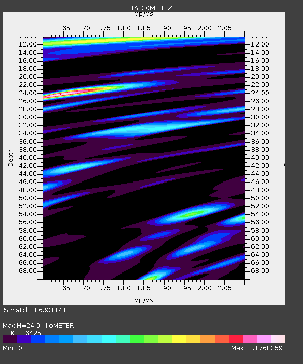
| Estimated Moho Depth: |
24.0 km |
| Estimated Crust Vp/Vs: |
1.64 |
| Assumed Crust Vp: |
6.566 km/s |
| Estimated Crust Vs: |
3.998 km/s |
| Estimated Crust Poisson's Ratio: |
0.21 |
|
| Radial Match: |
86.93373 % |
| Radial Bump: |
400 |
| Transverse Match: |
75.30919 % |
| Transverse Bump: |
400 |
| SOD ConfigId: |
20906531 |
| Insert Time: |
2020-04-08 11:29:22.137 +0000 |
| GWidth: |
2.5 |
| Max Bumps: |
400 |
| Tol: |
0.001 |
|
Signal To Noise
| Channel | StoN | STA | LTA |
| TA:I30M: :BHZ:20200317T16:18:28.47498Z | 3.0358915 | 4.9201014E-7 | 1.6206448E-7 |
| TA:I30M: :BHN:20200317T16:18:28.47498Z | 1.1697283 | 9.522036E-8 | 8.140383E-8 |
| TA:I30M: :BHE:20200317T16:18:28.47498Z | 2.0223336 | 1.4414523E-7 | 7.127668E-8 |
| Arrivals |
| Ps | 2.4 SECOND |
| PpPs | 9.4 SECOND |
| PsPs/PpSs | 12 SECOND |


