You are here: Home > Network List > TA - USArray Transportable Network (new EarthScope stations) Stations List
> Station K15K Wolf Creek Mountain, AK, USA > Earthquake Result Viewer
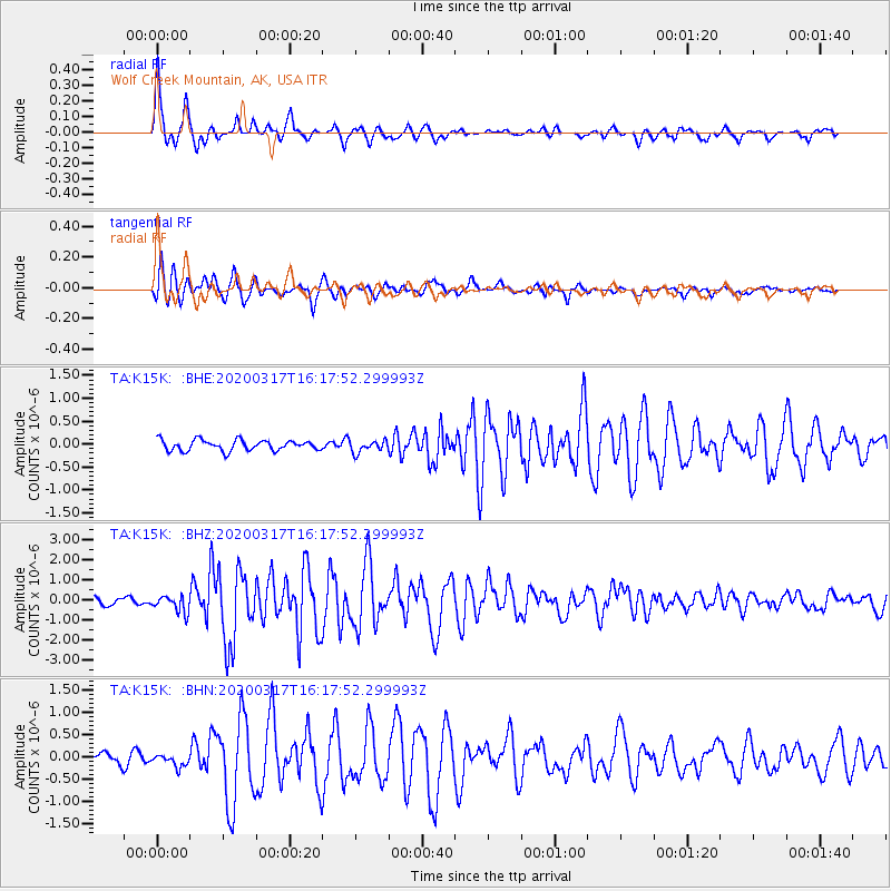
K15K Wolf Creek Mountain, AK, USA - Earthquake Result Viewer
*The percent match for this event was below the threshold and hence no stack was calculated.
| Earthquake location: |
Samoa Islands Region |
| Earthquake latitude/longitude: |
-16.0/-172.2 |
| Earthquake time(UTC): |
2020/03/17 (077) 16:06:22 GMT |
| Earthquake Depth: |
10 km |
| Earthquake Magnitude: |
6.0 mww |
| Earthquake Catalog/Contributor: |
NEIC PDE/us |
|
| Network: |
TA USArray Transportable Network (new EarthScope stations) |
| Station: |
K15K Wolf Creek Mountain, AK, USA |
| Lat/Lon: |
62.29 N/161.53 W |
| Elevation: |
346 m |
|
| Distance: |
78.5 deg |
| Az: |
5.062 deg |
| Baz: |
190.459 deg |
| Ray Param: |
$rayparam |
*The percent match for this event was below the threshold and hence was not used in the summary stack. |
|
| Radial Match: |
93.26566 % |
| Radial Bump: |
336 |
| Transverse Match: |
91.17697 % |
| Transverse Bump: |
400 |
| SOD ConfigId: |
20906531 |
| Insert Time: |
2020-04-08 11:29:28.770 +0000 |
| GWidth: |
2.5 |
| Max Bumps: |
400 |
| Tol: |
0.001 |
|
Signal To Noise
| Channel | StoN | STA | LTA |
| TA:K15K: :BHZ:20200317T16:17:52.299993Z | 2.8282416 | 4.1209248E-7 | 1.4570625E-7 |
| TA:K15K: :BHN:20200317T16:17:52.299993Z | 0.8263002 | 1.327822E-7 | 1.6069488E-7 |
| TA:K15K: :BHE:20200317T16:17:52.299993Z | 1.1230236 | 1.2912844E-7 | 1.1498284E-7 |
| Arrivals |
| Ps | |
| PpPs | |
| PsPs/PpSs | |


