You are here: Home > Network List > TA - USArray Transportable Network (new EarthScope stations) Stations List
> Station K17K Iditarod, AK, USA > Earthquake Result Viewer
K17K Iditarod, AK, USA - Earthquake Result Viewer
| Earthquake location: |
Samoa Islands Region |
| Earthquake latitude/longitude: |
-16.0/-172.2 |
| Earthquake time(UTC): |
2020/03/17 (077) 16:06:22 GMT |
| Earthquake Depth: |
10 km |
| Earthquake Magnitude: |
6.0 mww |
| Earthquake Catalog/Contributor: |
NEIC PDE/us |
|
| Network: |
TA USArray Transportable Network (new EarthScope stations) |
| Station: |
K17K Iditarod, AK, USA |
| Lat/Lon: |
62.72 N/158.30 W |
| Elevation: |
339 m |
|
| Distance: |
79.2 deg |
| Az: |
6.466 deg |
| Baz: |
193.59 deg |
| Ray Param: |
0.04910324 |
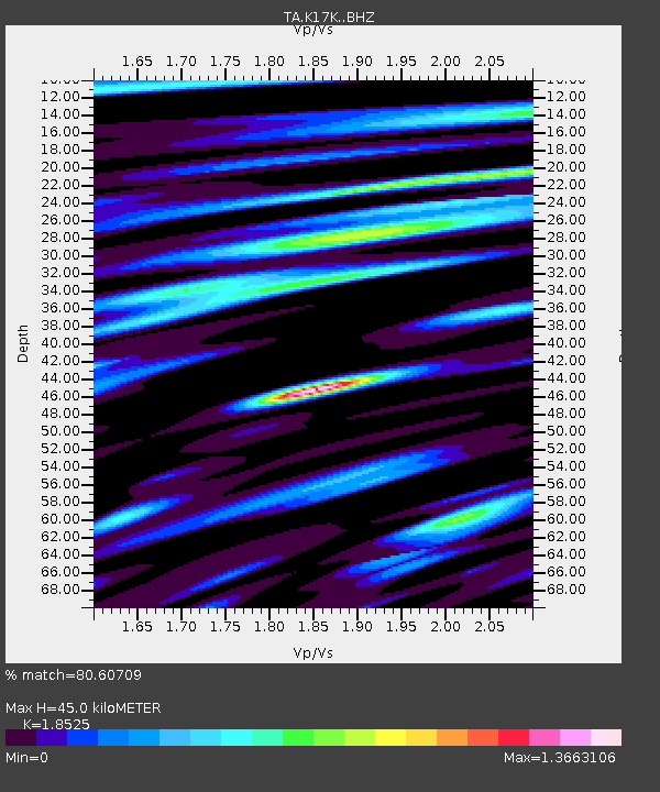
| Estimated Moho Depth: |
45.0 km |
| Estimated Crust Vp/Vs: |
1.85 |
| Assumed Crust Vp: |
6.276 km/s |
| Estimated Crust Vs: |
3.388 km/s |
| Estimated Crust Poisson's Ratio: |
0.29 |
|
| Radial Match: |
80.60709 % |
| Radial Bump: |
400 |
| Transverse Match: |
78.30223 % |
| Transverse Bump: |
400 |
| SOD ConfigId: |
20906531 |
| Insert Time: |
2020-04-08 11:29:30.270 +0000 |
| GWidth: |
2.5 |
| Max Bumps: |
400 |
| Tol: |
0.001 |
|

Signal To Noise
| Channel | StoN | STA | LTA |
| TA:K17K: :BHZ:20200317T16:17:56.275029Z | 1.9931144 | 3.154976E-7 | 1.5829377E-7 |
| TA:K17K: :BHN:20200317T16:17:56.275029Z | 1.6431466 | 1.8862238E-7 | 1.147934E-7 |
| TA:K17K: :BHE:20200317T16:17:56.275029Z | 0.8041525 | 1.109352E-7 | 1.3795294E-7 |
| Arrivals |
| Ps | 6.3 SECOND |
| PpPs | 20 SECOND |
| PsPs/PpSs | 26 SECOND |


