You are here: Home > Network List > TA - USArray Transportable Network (new EarthScope stations) Stations List
> Station L17K Donlin, AK, USA > Earthquake Result Viewer
L17K Donlin, AK, USA - Earthquake Result Viewer
| Earthquake location: |
Samoa Islands Region |
| Earthquake latitude/longitude: |
-16.0/-172.2 |
| Earthquake time(UTC): |
2020/03/17 (077) 16:06:22 GMT |
| Earthquake Depth: |
10 km |
| Earthquake Magnitude: |
6.0 mww |
| Earthquake Catalog/Contributor: |
NEIC PDE/us |
|
| Network: |
TA USArray Transportable Network (new EarthScope stations) |
| Station: |
L17K Donlin, AK, USA |
| Lat/Lon: |
62.13 N/158.30 W |
| Elevation: |
338 m |
|
| Distance: |
78.7 deg |
| Az: |
6.607 deg |
| Baz: |
193.621 deg |
| Ray Param: |
0.04948626 |
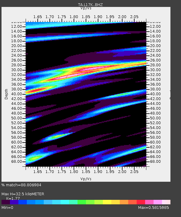
| Estimated Moho Depth: |
32.5 km |
| Estimated Crust Vp/Vs: |
1.77 |
| Assumed Crust Vp: |
6.276 km/s |
| Estimated Crust Vs: |
3.546 km/s |
| Estimated Crust Poisson's Ratio: |
0.27 |
|
| Radial Match: |
88.806984 % |
| Radial Bump: |
275 |
| Transverse Match: |
80.499 % |
| Transverse Bump: |
400 |
| SOD ConfigId: |
20906531 |
| Insert Time: |
2020-04-08 11:29:35.239 +0000 |
| GWidth: |
2.5 |
| Max Bumps: |
400 |
| Tol: |
0.001 |
|

Signal To Noise
| Channel | StoN | STA | LTA |
| TA:L17K: :BHZ:20200317T16:17:53.174993Z | 2.4556339 | 3.3653654E-7 | 1.3704671E-7 |
| TA:L17K: :BHN:20200317T16:17:53.174993Z | 1.8225628 | 2.487044E-7 | 1.3645862E-7 |
| TA:L17K: :BHE:20200317T16:17:53.174993Z | 1.1790625 | 2.2099799E-7 | 1.8743535E-7 |
| Arrivals |
| Ps | 4.1 SECOND |
| PpPs | 14 SECOND |
| PsPs/PpSs | 18 SECOND |


