You are here: Home > Network List > TA - USArray Transportable Network (new EarthScope stations) Stations List
> Station M24K Tolsona, Glennallen, AK, USA > Earthquake Result Viewer
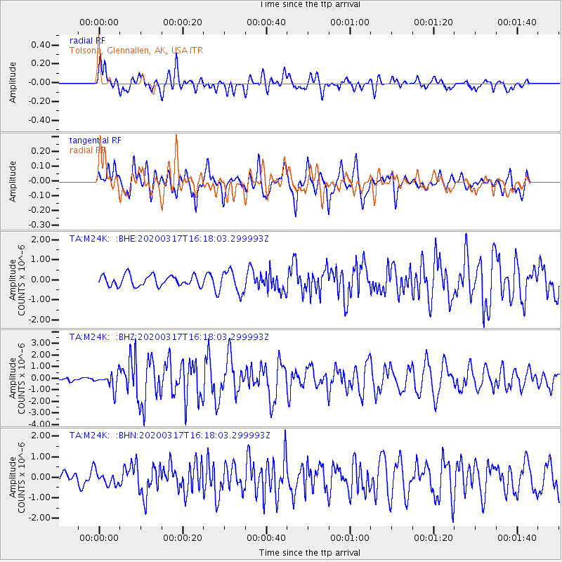
M24K Tolsona, Glennallen, AK, USA - Earthquake Result Viewer
*The percent match for this event was below the threshold and hence no stack was calculated.
| Earthquake location: |
Samoa Islands Region |
| Earthquake latitude/longitude: |
-16.0/-172.2 |
| Earthquake time(UTC): |
2020/03/17 (077) 16:06:22 GMT |
| Earthquake Depth: |
10 km |
| Earthquake Magnitude: |
6.0 mww |
| Earthquake Catalog/Contributor: |
NEIC PDE/us |
|
| Network: |
TA USArray Transportable Network (new EarthScope stations) |
| Station: |
M24K Tolsona, Glennallen, AK, USA |
| Lat/Lon: |
62.11 N/146.18 W |
| Elevation: |
908 m |
|
| Distance: |
80.5 deg |
| Az: |
12.071 deg |
| Baz: |
205.316 deg |
| Ray Param: |
$rayparam |
*The percent match for this event was below the threshold and hence was not used in the summary stack. |
|
| Radial Match: |
73.2705 % |
| Radial Bump: |
400 |
| Transverse Match: |
74.82888 % |
| Transverse Bump: |
400 |
| SOD ConfigId: |
20906531 |
| Insert Time: |
2020-04-08 11:29:46.080 +0000 |
| GWidth: |
2.5 |
| Max Bumps: |
400 |
| Tol: |
0.001 |
|
Signal To Noise
| Channel | StoN | STA | LTA |
| TA:M24K: :BHZ:20200317T16:18:03.299993Z | 2.3165364 | 7.1211406E-7 | 3.0740463E-7 |
| TA:M24K: :BHN:20200317T16:18:03.299993Z | 0.7440753 | 2.9158807E-7 | 3.9187978E-7 |
| TA:M24K: :BHE:20200317T16:18:03.299993Z | 2.0747013 | 5.4750734E-7 | 2.6389694E-7 |
| Arrivals |
| Ps | |
| PpPs | |
| PsPs/PpSs | |


