You are here: Home > Network List > US - United States National Seismic Network Stations List
> Station AMTX Amarillo, Texas, USA > Earthquake Result Viewer
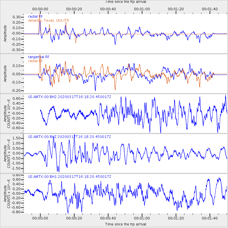
AMTX Amarillo, Texas, USA - Earthquake Result Viewer
*The percent match for this event was below the threshold and hence no stack was calculated.
| Earthquake location: |
Samoa Islands Region |
| Earthquake latitude/longitude: |
-16.0/-172.2 |
| Earthquake time(UTC): |
2020/03/17 (077) 16:06:22 GMT |
| Earthquake Depth: |
10 km |
| Earthquake Magnitude: |
6.0 mww |
| Earthquake Catalog/Contributor: |
NEIC PDE/us |
|
| Network: |
US United States National Seismic Network |
| Station: |
AMTX Amarillo, Texas, USA |
| Lat/Lon: |
34.53 N/101.41 W |
| Elevation: |
1010 m |
|
| Distance: |
83.9 deg |
| Az: |
51.633 deg |
| Baz: |
245.957 deg |
| Ray Param: |
$rayparam |
*The percent match for this event was below the threshold and hence was not used in the summary stack. |
|
| Radial Match: |
69.02761 % |
| Radial Bump: |
400 |
| Transverse Match: |
33.30884 % |
| Transverse Bump: |
400 |
| SOD ConfigId: |
20906531 |
| Insert Time: |
2020-04-08 11:31:41.450 +0000 |
| GWidth: |
2.5 |
| Max Bumps: |
400 |
| Tol: |
0.001 |
|
Signal To Noise
| Channel | StoN | STA | LTA |
| US:AMTX:00:BHZ:20200317T16:18:20.450017Z | 3.6606097 | 5.5585525E-7 | 1.5184773E-7 |
| US:AMTX:00:BH1:20200317T16:18:20.450017Z | 1.1442941 | 1.4905412E-7 | 1.3025857E-7 |
| US:AMTX:00:BH2:20200317T16:18:20.450017Z | 1.072978 | 1.8033136E-7 | 1.6806622E-7 |
| Arrivals |
| Ps | |
| PpPs | |
| PsPs/PpSs | |


