You are here: Home > Network List > US - United States National Seismic Network Stations List
> Station MSO Missoula, Montana, USA > Earthquake Result Viewer
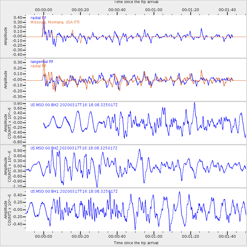
MSO Missoula, Montana, USA - Earthquake Result Viewer
*The percent match for this event was below the threshold and hence no stack was calculated.
| Earthquake location: |
Samoa Islands Region |
| Earthquake latitude/longitude: |
-16.0/-172.2 |
| Earthquake time(UTC): |
2020/03/17 (077) 16:06:22 GMT |
| Earthquake Depth: |
10 km |
| Earthquake Magnitude: |
6.0 mww |
| Earthquake Catalog/Contributor: |
NEIC PDE/us |
|
| Network: |
US United States National Seismic Network |
| Station: |
MSO Missoula, Montana, USA |
| Lat/Lon: |
46.83 N/113.94 W |
| Elevation: |
1264 m |
|
| Distance: |
81.5 deg |
| Az: |
36.183 deg |
| Baz: |
235.775 deg |
| Ray Param: |
$rayparam |
*The percent match for this event was below the threshold and hence was not used in the summary stack. |
|
| Radial Match: |
73.444626 % |
| Radial Bump: |
400 |
| Transverse Match: |
62.53956 % |
| Transverse Bump: |
400 |
| SOD ConfigId: |
20906531 |
| Insert Time: |
2020-04-08 11:32:00.961 +0000 |
| GWidth: |
2.5 |
| Max Bumps: |
400 |
| Tol: |
0.001 |
|
Signal To Noise
| Channel | StoN | STA | LTA |
| US:MSO:00:BHZ:20200317T16:18:08.325017Z | 2.5255072 | 4.2043126E-7 | 1.6647398E-7 |
| US:MSO:00:BH1:20200317T16:18:08.325017Z | 1.7293568 | 2.0406658E-7 | 1.1800143E-7 |
| US:MSO:00:BH2:20200317T16:18:08.325017Z | 0.47842965 | 1.0554889E-7 | 2.2061528E-7 |
| Arrivals |
| Ps | |
| PpPs | |
| PsPs/PpSs | |


