You are here: Home > Network List > UU - University of Utah Regional Network Stations List
> Station ECUT Ebbs Canyon, Scipio, UT, USA > Earthquake Result Viewer
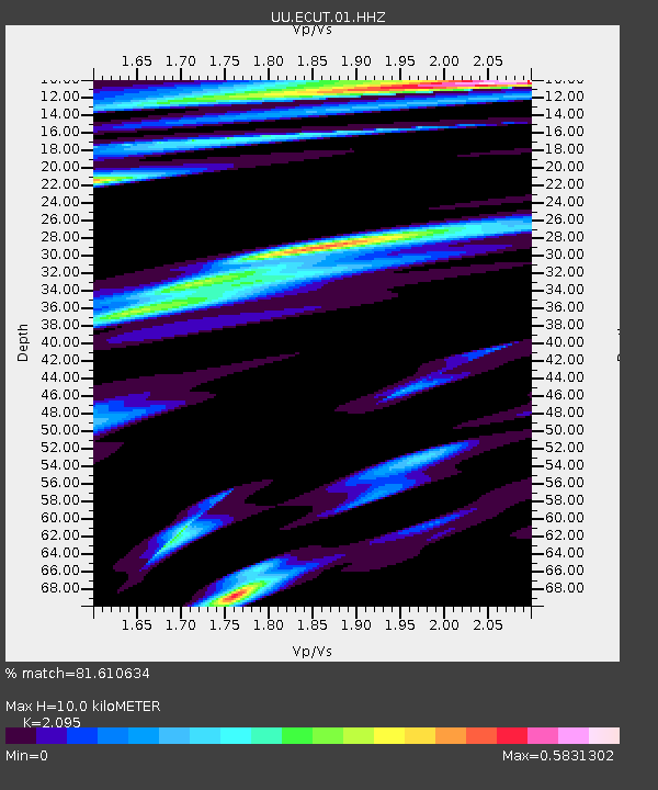
ECUT Ebbs Canyon, Scipio, UT, USA - Earthquake Result Viewer
| Earthquake location: |
Samoa Islands Region |
| Earthquake latitude/longitude: |
-16.0/-172.2 |
| Earthquake time(UTC): |
2020/03/17 (077) 16:06:22 GMT |
| Earthquake Depth: |
10 km |
| Earthquake Magnitude: |
6.0 mww |
| Earthquake Catalog/Contributor: |
NEIC PDE/us |
|
| Network: |
UU University of Utah Regional Network |
| Station: |
ECUT Ebbs Canyon, Scipio, UT, USA |
| Lat/Lon: |
39.17 N/112.13 W |
| Elevation: |
2136 m |
|
| Distance: |
78.4 deg |
| Az: |
43.436 deg |
| Baz: |
238.272 deg |
| Ray Param: |
0.049648784 |
| Estimated Moho Depth: |
10.0 km |
| Estimated Crust Vp/Vs: |
2.10 |
| Assumed Crust Vp: |
6.276 km/s |
| Estimated Crust Vs: |
2.996 km/s |
| Estimated Crust Poisson's Ratio: |
0.35 |
|
| Radial Match: |
81.610634 % |
| Radial Bump: |
400 |
| Transverse Match: |
62.917973 % |
| Transverse Bump: |
400 |
| SOD ConfigId: |
20906531 |
| Insert Time: |
2020-04-08 11:32:16.206 +0000 |
| GWidth: |
2.5 |
| Max Bumps: |
400 |
| Tol: |
0.001 |
|

Signal To Noise
| Channel | StoN | STA | LTA |
| UU:ECUT:01:HHZ:20200317T16:17:51.85999Z | 1.1852427 | 6.0322924E-9 | 5.0895004E-9 |
| UU:ECUT:01:HHN:20200317T16:17:51.85999Z | 1.0814015 | 6.397888E-9 | 5.916293E-9 |
| UU:ECUT:01:HHE:20200317T16:17:51.85999Z | 1.7134241 | 4.2325374E-9 | 2.4702216E-9 |
| Arrivals |
| Ps | 1.8 SECOND |
| PpPs | 4.8 SECOND |
| PsPs/PpSs | 6.6 SECOND |


