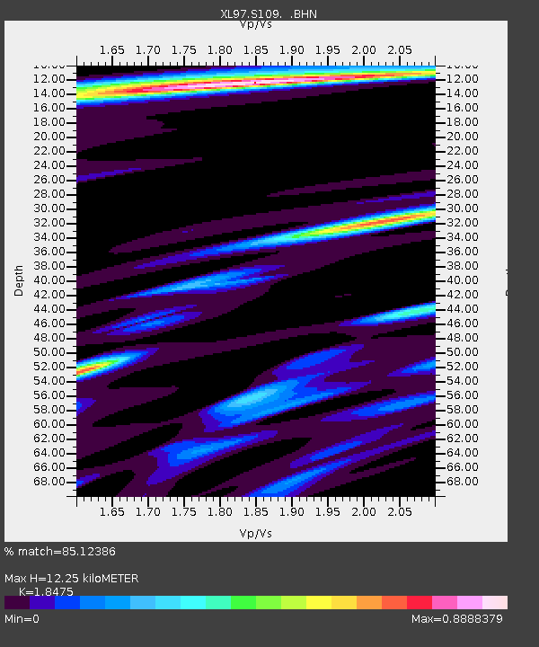
S109 South Superior - Earthquake Result Viewer
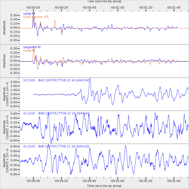
Earthquake location: Tonga Islands
Earthquake latitude/longitude: -15.2/-173.3
Earthquake time(UTC): 1997/05/27 (147) 08:00:29 GMT
Earthquake Depth: 14 km
Earthquake Magnitude: 5.6 MB, 6.3 MS, 6.4 UNKNOWN, 5.7 ME
Earthquake Catalog/Contributor: WHDF/NEIC
Network: XL Deep Probe (Archean-Proterozoic)
Station: S109 South Superior
Lat/Lon: 41.73 N/108.92 W
Elevation: 2065 m
Distance: 82.0 deg
Az: 42.981 deg
Baz: 241.555 deg
Ray Param: 0.047186684
Estimated Moho Depth: 12.25 km
Estimated Crust Vp/Vs: 1.85
Assumed Crust Vp: 6.207 km/s
Estimated Crust Vs: 3.36 km/s
Estimated Crust Poisson's Ratio: 0.29
Radial Match: 85.12386 %
Radial Bump: 333
Transverse Match: 71.20454 %
Transverse Bump: 400
SOD ConfigId: 6273
Insert Time: 2010-03-08 18:18:09.822 +0000
GWidth: 2.5
Max Bumps: 400
Tol: 0.001

Signal To Noise

ChannelStoNSTALTA
XL:S109: :BHN:19970527T08:12:16.994019Z1.72730961.7918681E-71.0373753E-7
XL:S109: :BHE:19970527T08:12:16.994019Z1.67018512.1706025E-71.2996179E-7
XL:S109: :BHZ:19970527T08:12:16.994019Z7.36956835.6707296E-77.694792E-8
Arrivals
Ps1.7 SECOND
PpPs5.5 SECOND
PsPs/PpSs7.2 SECOND