You are here: Home > Network List > UW - Pacific Northwest Regional Seismic Network Stations List
> Station BERY Pilchuck Tree Farm, Arlington, WA, USA > Earthquake Result Viewer
BERY Pilchuck Tree Farm, Arlington, WA, USA - Earthquake Result Viewer
| Earthquake location: |
Samoa Islands Region |
| Earthquake latitude/longitude: |
-16.0/-172.2 |
| Earthquake time(UTC): |
2020/03/17 (077) 16:06:22 GMT |
| Earthquake Depth: |
10 km |
| Earthquake Magnitude: |
6.0 mww |
| Earthquake Catalog/Contributor: |
NEIC PDE/us |
|
| Network: |
UW Pacific Northwest Regional Seismic Network |
| Station: |
BERY Pilchuck Tree Farm, Arlington, WA, USA |
| Lat/Lon: |
48.26 N/122.10 W |
| Elevation: |
150 m |
|
| Distance: |
78.0 deg |
| Az: |
31.604 deg |
| Baz: |
228.954 deg |
| Ray Param: |
0.049958054 |
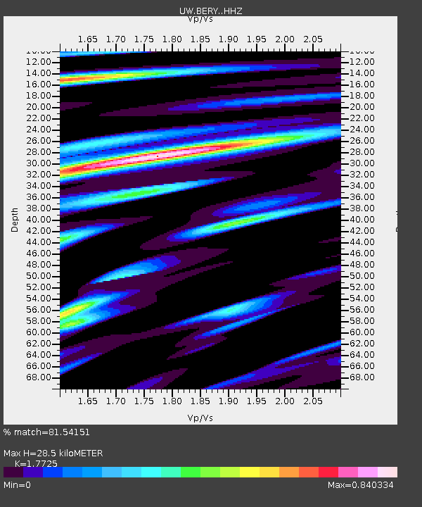
| Estimated Moho Depth: |
28.5 km |
| Estimated Crust Vp/Vs: |
1.77 |
| Assumed Crust Vp: |
6.566 km/s |
| Estimated Crust Vs: |
3.704 km/s |
| Estimated Crust Poisson's Ratio: |
0.27 |
|
| Radial Match: |
81.54151 % |
| Radial Bump: |
400 |
| Transverse Match: |
63.0387 % |
| Transverse Bump: |
400 |
| SOD ConfigId: |
20906531 |
| Insert Time: |
2020-04-08 11:32:39.256 +0000 |
| GWidth: |
2.5 |
| Max Bumps: |
400 |
| Tol: |
0.001 |
|

Signal To Noise
| Channel | StoN | STA | LTA |
| UW:BERY: :HHZ:20200317T16:17:49.409978Z | 2.7141469 | 3.981571E-7 | 1.4669696E-7 |
| UW:BERY: :HHN:20200317T16:17:49.409978Z | 1.4854112 | 2.0391222E-7 | 1.3727661E-7 |
| UW:BERY: :HHE:20200317T16:17:49.409978Z | 1.5493783 | 2.134848E-7 | 1.3778738E-7 |
| Arrivals |
| Ps | 3.5 SECOND |
| PpPs | 12 SECOND |
| PsPs/PpSs | 15 SECOND |


