You are here: Home > Network List > WY - Yellowstone Wyoming Seismic Network Stations List
> Station YHH Holmes Hill, YNP, WY, USA > Earthquake Result Viewer
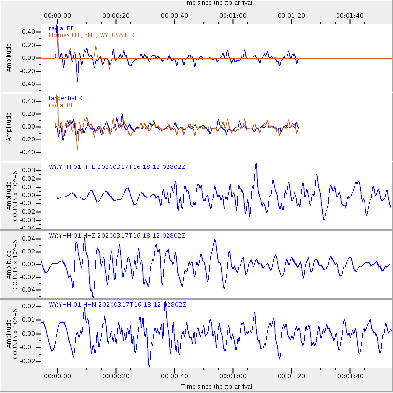
YHH Holmes Hill, YNP, WY, USA - Earthquake Result Viewer
*The percent match for this event was below the threshold and hence no stack was calculated.
| Earthquake location: |
Samoa Islands Region |
| Earthquake latitude/longitude: |
-16.0/-172.2 |
| Earthquake time(UTC): |
2020/03/17 (077) 16:06:22 GMT |
| Earthquake Depth: |
10 km |
| Earthquake Magnitude: |
6.0 mww |
| Earthquake Catalog/Contributor: |
NEIC PDE/us |
|
| Network: |
WY Yellowstone Wyoming Seismic Network |
| Station: |
YHH Holmes Hill, YNP, WY, USA |
| Lat/Lon: |
44.79 N/110.85 W |
| Elevation: |
2717 m |
|
| Distance: |
82.2 deg |
| Az: |
39.1 deg |
| Baz: |
238.398 deg |
| Ray Param: |
$rayparam |
*The percent match for this event was below the threshold and hence was not used in the summary stack. |
|
| Radial Match: |
79.96171 % |
| Radial Bump: |
400 |
| Transverse Match: |
82.80958 % |
| Transverse Bump: |
400 |
| SOD ConfigId: |
20906531 |
| Insert Time: |
2020-04-08 11:33:32.210 +0000 |
| GWidth: |
2.5 |
| Max Bumps: |
400 |
| Tol: |
0.001 |
|
Signal To Noise
| Channel | StoN | STA | LTA |
| WY:YHH:01:HHZ:20200317T16:18:12.02802Z | 2.3100145 | 9.713907E-9 | 4.2051282E-9 |
| WY:YHH:01:HHN:20200317T16:18:12.02802Z | 2.5968308 | 6.7442727E-9 | 2.5971165E-9 |
| WY:YHH:01:HHE:20200317T16:18:12.02802Z | 0.4231649 | 1.7760611E-9 | 4.19709E-9 |
| Arrivals |
| Ps | |
| PpPs | |
| PsPs/PpSs | |


