You are here: Home > Network List > TS - TERRAscope (Southern California Seismic Network) Stations List
> Station PFO Pinon Flat, California, USA > Earthquake Result Viewer
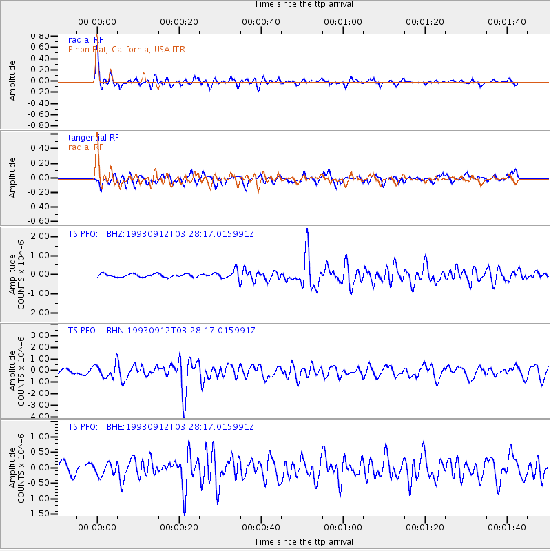
PFO Pinon Flat, California, USA - Earthquake Result Viewer
*The percent match for this event was below the threshold and hence no stack was calculated.
| Earthquake location: |
Near Coast Of Guatemala |
| Earthquake latitude/longitude: |
13.8/-90.5 |
| Earthquake time(UTC): |
1993/09/12 (255) 03:22:38 GMT |
| Earthquake Depth: |
69 km |
| Earthquake Magnitude: |
5.6 MB |
| Earthquake Catalog/Contributor: |
WHDF/NEIC |
|
| Network: |
TS TERRAscope (Southern California Seismic Network) |
| Station: |
PFO Pinon Flat, California, USA |
| Lat/Lon: |
33.61 N/116.46 W |
| Elevation: |
1280 m |
|
| Distance: |
30.7 deg |
| Az: |
314.33 deg |
| Baz: |
123.626 deg |
| Ray Param: |
$rayparam |
*The percent match for this event was below the threshold and hence was not used in the summary stack. |
|
| Radial Match: |
79.34614 % |
| Radial Bump: |
400 |
| Transverse Match: |
72.08566 % |
| Transverse Bump: |
400 |
| SOD ConfigId: |
4480 |
| Insert Time: |
2010-02-26 14:44:19.156 +0000 |
| GWidth: |
2.5 |
| Max Bumps: |
400 |
| Tol: |
0.001 |
|
Signal To Noise
| Channel | StoN | STA | LTA |
| TS:PFO: :BHN:19930912T03:28:17.015991Z | 2.826084 | 5.932207E-7 | 2.0990909E-7 |
| TS:PFO: :BHE:19930912T03:28:17.015991Z | 0.9706917 | 1.8481391E-7 | 1.9039405E-7 |
| TS:PFO: :BHZ:19930912T03:28:17.015991Z | 3.0218534 | 2.436687E-7 | 8.063551E-8 |
| Arrivals |
| Ps | |
| PpPs | |
| PsPs/PpSs | |


