You are here: Home > Network List > XL97 - Deep Probe (Archean-Proterozoic) Stations List
> Station S209 Lyman > Earthquake Result Viewer
S209 Lyman - Earthquake Result Viewer

| Earthquake location: |
South Of Fiji Islands |
| Earthquake latitude/longitude: |
-26.6/178.3 |
| Earthquake time(UTC): |
1997/09/04 (247) 04:23:37 GMT |
| Earthquake Depth: |
625 km |
| Earthquake Magnitude: |
6.3 MB, 6.8 UNKNOWN, 6.5 ME |
| Earthquake Catalog/Contributor: |
WHDF/NEIC |
|
| Network: |
XL Deep Probe (Archean-Proterozoic) |
| Station: |
S209 Lyman |
| Lat/Lon: |
41.36 N/110.19 W |
| Elevation: |
2002 m |
|
| Distance: |
94.5 deg |
| Az: |
45.719 deg |
| Baz: |
238.408 deg |
| Ray Param: |
0.040381994 |
| Estimated Moho Depth: |
63.75 km |
| Estimated Crust Vp/Vs: |
2.02 |
| Assumed Crust Vp: |
6.155 km/s |
| Estimated Crust Vs: |
3.051 km/s |
| Estimated Crust Poisson's Ratio: |
0.34 |
|
| Radial Match: |
90.27223 % |
| Radial Bump: |
400 |
| Transverse Match: |
90.00611 % |
| Transverse Bump: |
400 |
| SOD ConfigId: |
6273 |
| Insert Time: |
2010-03-08 18:18:28.833 +0000 |
| GWidth: |
2.5 |
| Max Bumps: |
400 |
| Tol: |
0.001 |
|
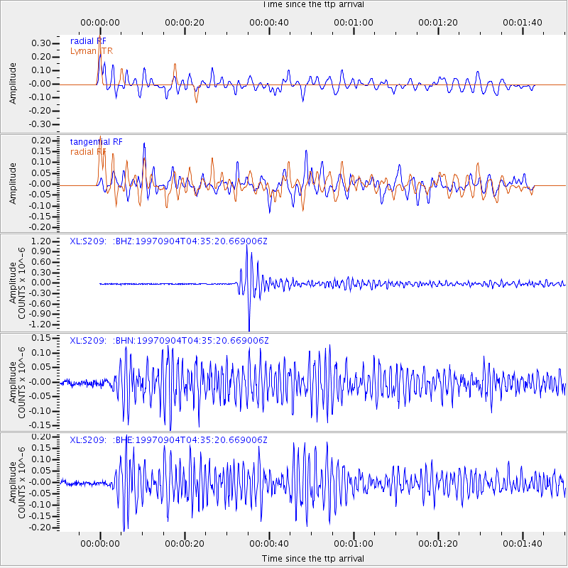
Signal To Noise
| Channel | StoN | STA | LTA |
| XL:S209: :BHN:19970904T04:35:20.669006Z | 3.5844395 | 2.5425027E-8 | 7.093167E-9 |
| XL:S209: :BHE:19970904T04:35:20.669006Z | 5.6245584 | 3.806752E-8 | 6.76809E-9 |
| XL:S209: :BHZ:19970904T04:35:20.669006Z | 34.07857 | 2.5154762E-7 | 7.3814017E-9 |
| Arrivals |
| Ps | 11 SECOND |
| PpPs | 31 SECOND |
| PsPs/PpSs | 41 SECOND |


