You are here: Home > Network List > TA - USArray Transportable Network (new EarthScope stations) Stations List
> Station D20K Etivluk River, AK, USA > Earthquake Result Viewer
D20K Etivluk River, AK, USA - Earthquake Result Viewer
| Earthquake location: |
North Of Halmahera, Indonesia |
| Earthquake latitude/longitude: |
3.0/128.0 |
| Earthquake time(UTC): |
2020/03/18 (078) 03:13:29 GMT |
| Earthquake Depth: |
102 km |
| Earthquake Magnitude: |
5.4 Mww |
| Earthquake Catalog/Contributor: |
NEIC PDE/us |
|
| Network: |
TA USArray Transportable Network (new EarthScope stations) |
| Station: |
D20K Etivluk River, AK, USA |
| Lat/Lon: |
68.71 N/156.61 W |
| Elevation: |
577 m |
|
| Distance: |
81.9 deg |
| Az: |
20.907 deg |
| Baz: |
257.395 deg |
| Ray Param: |
0.04704401 |
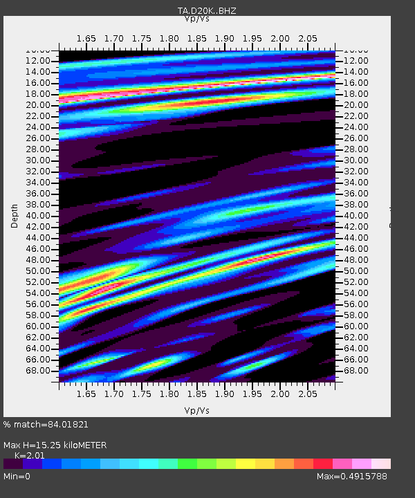
| Estimated Moho Depth: |
15.25 km |
| Estimated Crust Vp/Vs: |
2.01 |
| Assumed Crust Vp: |
6.221 km/s |
| Estimated Crust Vs: |
3.095 km/s |
| Estimated Crust Poisson's Ratio: |
0.34 |
|
| Radial Match: |
84.01821 % |
| Radial Bump: |
400 |
| Transverse Match: |
80.59976 % |
| Transverse Bump: |
400 |
| SOD ConfigId: |
20906531 |
| Insert Time: |
2020-04-08 11:42:05.544 +0000 |
| GWidth: |
2.5 |
| Max Bumps: |
400 |
| Tol: |
0.001 |
|

Signal To Noise
| Channel | StoN | STA | LTA |
| TA:D20K: :BHZ:20200318T03:25:06.799991Z | 5.331035 | 7.4112506E-7 | 1.3902086E-7 |
| TA:D20K: :BHN:20200318T03:25:06.799991Z | 1.9425762 | 1.8481808E-7 | 9.514071E-8 |
| TA:D20K: :BHE:20200318T03:25:06.799991Z | 2.6820982 | 2.8333884E-7 | 1.05640744E-7 |
| Arrivals |
| Ps | 2.5 SECOND |
| PpPs | 7.2 SECOND |
| PsPs/PpSs | 9.7 SECOND |


